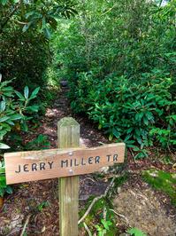
Jerry Miller Trail

At A Glance


4.5 mi one-way
Difficulty Rating: 4.5 ![]()
Steepness: Climbs Steeply ![]()
Tread Condition: Moderately Rough ![]()
Blaze Color: Yellow
Trail Number: 286
Description
Formerly known as the Whiteoak Flats trail. The trail leaves FS 111 from parking on the road’s left side. The trail is especially scenic in late spring when the rhododendron and mountain laurel are in bloom.
Crossing Big Creek and climbing a narrow ridge, the trail gradually drops to an old logging road along Whiteoak Flats branch. The trail runs into the Whiteoak Flats wildlife opening. The trail then follows the old road for three miles and becomes a foot trail that climbs through heavy brush. The trail then connects with the Appalachian Trail at Bear Wallow Gap. This last section of trail is not well marked or worn from use. No markers or directional signs are located at the Appalachian Trail intersection.
The official Forest Service literature on this one says "While on the trail you will be able to view a 100 foot high waterfall". I've never seen the falls myself, and I've seen several references that seem to indicate that it just doesn't exist. ~~In fact, I'm thinking this might be confused with a Whiteoak Flats Branch Falls in the nearby Great Smoky Mountains National Park. A mystery for another hike, I suppose.~~
Edit November 2014: the waterfall definitely exists, it's just not 100 feet high. More like 100 feet long. It's nice when there's good water flow, but it's nothing to get too excited about.
Intersecting Trails
This trail is located in the Shelton Laurel Backcountry & Camp Creek Bald area. For a list of all the trails in that area, see the Shelton Laurel Backcountry & Camp Creek Bald trails list page.
All Photos from the Trail

GPS Map
Map Information
Download GPS Data
Click on a route, trail, or point on the map and select the GPS Data tab to download its data.
Data Formats
KML (Google Earth)
KML is the main file type used by Google Earth. If you have Google Earth installed, clicking the KML link should open the trail or point directly in Google Earth for viewing. This is the native file format used by Google Earth, but many other map applications can use and understand KML as well, so if you're not sure which one to download, KML is a good bet.
GPX
The GPX format stands for GPS Exchange - a free, open, XML format for exchanging GPS and map data. GPX is compatible with Google Earth, many other mapping programs, and most GPS devices (such as Garmin). Load the file directly into your GPS to help find your way on your next trip!
GeoJSON
GeoJSON is a newer, lightweight data exchange format which can be used to quickly share map data and may have a smaller size than KML or GPX. Many professional mapping and GIS applications support the GeoJSON format.
About the Map
Copyright
Base Layers
Base layers provided by OpenStreetMap, the US Geological Survey, the US Forest Service, and NC OneMap. Base layer images are subject to the respective copyright policies of their owners. Base layers may not be available at all times due to system maintenance or outages.
WNCOutdoors Base Layer
The WNCOutdoors Base layer is provided by WNCOutdoors.info. It is licensed by Creative Commons Attribution 3.0.
Trail and Marker Overlays
Trail layers and downloadable data are all original works created by WNCOutdoors with guidance from a variety of sources, including ensembles of our own GPS tracks, user contributed GPS tracks, official maps and GIS data from government agencies, and field observations. WNCOutdoors data is made freely available under the Open Database License - you are free to copy and use it for any purpose under the terms of that license (summary).
Tips
- Hover over a trail to see it highlighted. Helps to see start and end points for an individual trail.
- Scroll and zoom the map before printing, and that view will persist into the printed image.
- Click a trail for more details and to download it individually.
Trail Segments
Trails are often made up of several connecting paths which may have different characteristics, allowed uses, and seasons. This trail is divided into multiple segments as follows:
Jerry Miller - Big Creek Rd. to Hickey Fork Rd.
- Allowed Uses: Hiking
- Length: 1.73 mi
Jerry Miller - Hickey Fork to Upper Hickey Fork Rd
- Allowed Uses: Hiking
- Length: 1.19 mi
Jerry Miller - along Upper Hickey Fork Rd
- Allowed Uses: Hiking
- Length: 1.29 mi
Jerry Miller - Upper Hickey Fork to AT
- Allowed Uses: Hiking
- Length: 0.42 mi
Total Calculated Length: 4.62 mi
This value is derived from our underlying map data, and it may not match officially published information.
Feedback
Ratings
Average Rating: 3.0 (rated 2 times)
Rate It Now:

No comments yet.