Green Knob Hike

This hike takes you along the Mountains to Sea Trail in a remote section of the Pisgah National Forest. The entire hike is above 5000 ft in elevation, and you'll explore forests of oaks, birches, beeches, spruces and firs. You'll cross the headwaters of clear, cold mountain creeks and have a distant view of a high, thin, unnamed waterfall. You'll travel through rocky heath balds as well as grassy balds and patches of blueberries. Atop Green Knob, a spectacular view of the Flat Laurel Creek valley and Sam Knob awaits. If you're looking for solitude, hike to Green Knob!
At A Glance
 9 mi round-trip
Difficulty Rating: 12.01 ![]()
Tread Condition: Some Obstacles ![]()
Climb: Hilly ![]()
Lowest Elevation: 5080 ft
Highest Elevation: 5900 ft
Climb Total: 1200 ft
Configuration: Out-and-back
Starting Point: Mountains to Sea Trail access along NC 215, just north of the Blue Ridge Parkway
Trails Used: Green Mountain, Mountains to Sea Section 2
Hike Start Location
Directions
From Asheville, take I-40 west to NC 215 in Canton. Follow NC 215 South through Canton (follow signs, there are several turns). Continue on NC 215, past Lake Logan, and up the West Fork Pigeon River valley, to the parking area just before the Parkway on the right.
Alternate Route: Travel the Parkway south from Asheville, and exit on NC 215. Turn left; the parking area is just down the road on the left.
Details
Hike Description
Important: This hike is rated as More Difficult on the basis of climbing and tread surface alone. If you are not experienced with Wilderness travel, consider it Most Difficult.

It is essential to have a map and a compass and survival supplies for hikes in the Wilderness, especially at these high, exposed altitudes. No signs or blazes are available to guide you. Although it is fairly easy to follow this particular trail, grassy openings can make it nearly impossible to navigate when it is foggy or the trail is snow-covered, so hike this trail on a sunny day! Also, the trail runs along the tops of some cliff in places on Fork Ridge, so take precautions against falls.
The hike starts out on the Mountains to Sea Trail, on the same side of the road as the parking area. It's on the right if you came up 215 from Canton, and on the left if you came down from the Parkway. Begin hiking downhill in a northerly direction.
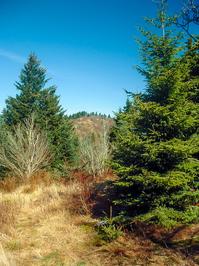
Very shortly, you'll reach a significant stream crossing (Bubbling Spring Branch). If the water is high, cross on the road just to your right and return to the trail to stay dry. Then, the trail enters a cool, high-elevation forest of mostly birch trees. You'll also encounter beeches, maples, Mountain Ash, Red spruce, and Fraser fir.
Some large, healthy examples of both Fraser Fir and Red Spruce can be found on this hike. Seeing them is encouraging since this forest type is under siege from several fronts: logging, invading insects, acid rain, and perhaps even a warming climate are all taking their toll on this rare ecosystem. Tree mortality in this area seems to be (for now) lower than average for this type of forest. You'll also find the essential Rhododendrons, Mountain Laurels, and dense thickets of Blueberries along the trail.
The entire hike will basically consist of this type of forest, and your altitude will increase from just above 5000 ft to just below 6000 ft. Before long, the trail will pick up on an old road or probably railroad bed, and begin a steady climb uphill.
You'll pass through the first and largest of the many grassy, open meadows found on this hike. This one is kept open by mowing; the rest are gradually becoming overgrown.
{{fig img="2008-04-06_pisgah-west-fork_mountains-to-sea-trail-meadow.jpg""}}
Beyond the big meadow, the trail wraps around the ridge and start heading south. It begins following an apparently unnamed stream gently uphill. The trail gradually gets closer to the stream, and it gets loud enough that it sounds like there may be a waterfall on the stream somewhere far below you. I haven't investigated to confirm this, however.

The road will eventually cross the stream right where two forks of it come together. You'll pass onto the spit of land between the two creeks and begin following the right fork upstream. Then the creek turns right, out of sight, into the rhododendron thicket. Not far uphill from that thicket is a significant waterfall, sometimes called Mount Hardy Falls. You'll enjoy a great view of it shortly!
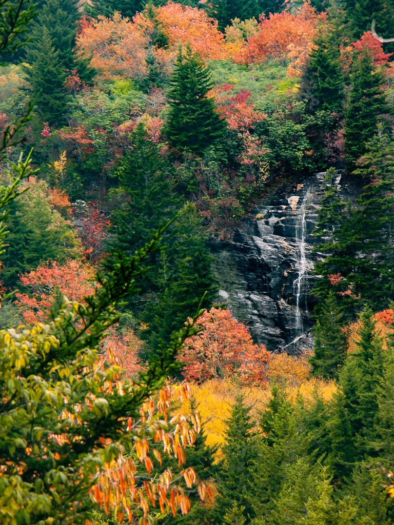
The trail curves left, becomes rather mushy, and crosses the left fork of the stream. It then begins angling up a low, broad ridge. After a few hundred yards, an opening in the trees presents a view of Mount Hardy Falls, which only flows significantly after wet weather. The slopes around the falls are covered by high-elevation spruces and firs, birch trees, and rhododendrons.
The trail switches back to the right through a hairpin turn, and another (even better) view of the falls opens up. Then you'll cross the far upper reaches of the stream's left fork again. In this headwaters area, all it consists of are some muddy bogs, seeps, and perhaps some tiny, distinct trickles of water. Makeshift log bridges might keep your feet dry, and if they do, they'll stay that way since the trail actually dries out some up ahead. As you approach the ridgeline, an attractive forest of healthy birch trees growing in a grassy gulch appears on your right.
The trail then slides off the left (south) side of the ridge. Now you can begin to hear cars on the Parkway below you on the left. You may also find a piece of rusty wire rope, or a railroad spike - remnants from the days of rampant logging in this area. Leave them alone, since relics like this are federally protected. Besides, the next person who hikes through here has a right to see and ponder these artifacts for themselves.

As you gradually swing back to the right toward Mount Hardy, a nice view of this peak and of Herrin Knob opens up on your left.
The trail crosses over the crest of the ridge once again, and then you'll start a climb up the same steep mountainside and cliff band over which the waterfall flows. At the top of this climb, you reach the small plateau above the falls. This is a high bench on the East flank of Mount Hardy. A Catawba rhododendron thicket grows here and it arches over the trail, forming a sort of tunnel.
Notice that the land around you on this bench is flatter than it has been so far during the hike. Not only does this give the stream a chance to grow before heading over the falls, but the little basin, filled with poorly drained soils and underlain with solid bedrock, supports an unusual habitat: a high elevation peat bog. Rare plants find their homes here and nowhere else. Elsewhere, this habitat is threatened by development and here, by trampling. So be sure to stay on the trail as you cross several small tributary streams, all headed for the brink of the falls.
The area around here, for a few miles' radius, is where two larger mountain ranges meet: the Pisgah Ridge, which runs northeast from here all the way to to Asheville, and the Balsam Mountains, which run northwest toward the Great Smoky Mountains. This broad junction contains a number of these characteristic high-altitude flats like the little bench you just traveled through - such as the better-known Flat Laurel Creek Valley and Graveyard Fields to the east.
You'll begin winding up the ridge on the north edge of the bench, and then you'll follow the ridge's crest until it joins the crest of Fork Ridge, which heads north from Mount Hardy.
You may find Pinkshell Azalea or Wretched Sedge in the crevices of rock outcrops. The forests here vaguely resemble ones out west in the Rockies in places, where you find tall conifers growing on grassy slopes. Thick, tangled undergrowth in other places, however, comprise a dead giveaway that you are in the wetter Appalachians. This combination of topography and weather also ensures that there are plenty of waterfalls here, another of which you will be seeing shortly!

As you approach the crest of Fork Ridge, you'll encounter the steepest climb on the hike yet, with a large grassy opening on your left. Just past the opening, you reach the summit of the ridge, and an un-signed trail joins from the right. This is the Green Mountain (formerly Fork Ridge) trail and it's where you will want to turn right to continue this hike. Since this trail is not signed, blazed, nor very heavily used - and tends to fade out in places - it is essential to have a map and compass to make it to Green Knob from here. It is not difficult, but do not even attempt to do so on a foggy day!
The forest at this point is primarily comprised of Red Spruce and Fraser Fir, with thick tangles of blackberries growing where they can get sunlight. But you will wind your way through some grassy openings as well, and also several saddles that contain the beginnings of a "Beech Gap" forest.
The Beech Gap forest occurs when American Beeches take hold in the saddles along a high ridge like this one, and then gradually monopolize the forest. These are like "deciduous islands" in the spruce-fir sea at this altitude. The short, stocky beech trees - shaped into "orchard vegetation" by the wind - provide an interesting and unique habitat once they become established. The way the trees grow and reproduce differs from stands of American beech at lower elevations. Here, the patches of beech trees are still small, yet will likely continue to grow until each saddle is filled with them, with grasses and sedges flowing beneath them. This is yet another fascinating anomaly of the Southern Appalachian forests.
Or at least, it was. A complex of pathogens - including a non-native insect and fungus - are killing off the beech trees. Called Beech Bark Disease, this is a potent killer and beech gaps all over the Appalachians have become infected died off in recent years. So if you still find the beech trees alive when you get here, consider yourself lucky to have seen them. Maybe you remember the tall, dark hemlocks which used to tower over the streams in lower elevations, too?

Continuing along Fork Ridge on the Green Mountain trail, you'll pass over two smaller summits and a couple of small knobs before ascending to Green Knob itself. It's not marked or signed, but green Knob is the first place where a significant view opens up to the left. That's one way to know that you're there. Also look for a larger grassy opening, at a point higher than all the surrounding terrain - or whip out the GPS if you have one of those with you. Either way, if the trail starts heading steeply downhill for a ways, you've probably gone past it!
Green Knob's summit is where this hike officially ends, and you'll find a nice campsite here with an astounding view of the ridge to your east. Most evident in the scene is Sam Knob with its characteristic double summit in the foreground. To the right of Sam Knob you can see Little Sam Knob, with Flat Laurel Creek cascading out of the high, relatively flat, grassy meadows between these two mountains. Behind and to the right of Sam Knob looms the long, grassy ridge of Black Balsam Knob and the sharp point of Tennent Mountain can be seen to the left of that.
Also, almost the entire path of the Flat Laurel Creek trail - an old logging railroad grade - can be seen, starting at Hwy. 215 on the right, to the parking area at the end of FS 816 (Black Balsam Road). Above the roadbed grows a thick Spruce/Fir forest. Below it grow mostly northern Hardwood trees with only scattered spruces and firs. If you look closely, you may be able to see FS 816 coming through the gap below Black Balsam Knob and heading down to the parking area at its end.
The hike is just long enough that some people choose to camp up here overnight, making for two short hikes rather than one long one. Whether you camp or just stay for a while to soak up some views, return to your vehicle following the same route to complete the hike.
All Photos from This Hike


Map
Green highlight indicates the route to follow within the trail network for this hike.
Tip: Printing this map? You can pan and zoom the map as desired before printing to show the area you need.
Map Information
Download GPS Data
Click on a route, trail, or point on the map and select the GPS Data tab to download its data.
Data Formats
KML (Google Earth)
KML is the main file type used by Google Earth. If you have Google Earth installed, clicking the KML link should open the trail or point directly in Google Earth for viewing. This is the native file format used by Google Earth, but many other map applications can use and understand KML as well, so if you're not sure which one to download, KML is a good bet.
GPX
The GPX format stands for GPS Exchange - a free, open, XML format for exchanging GPS and map data. GPX is compatible with Google Earth, many other mapping programs, and most GPS devices (such as Garmin). Load the file directly into your GPS to help find your way on your next trip!
GeoJSON
GeoJSON is a newer, lightweight data exchange format which can be used to quickly share map data and may have a smaller size than KML or GPX. Many professional mapping and GIS applications support the GeoJSON format.
About the Map
Copyright
Base Layers
Base layers provided by OpenStreetMap, the US Geological Survey, the US Forest Service, and NC OneMap. Base layer images are subject to the respective copyright policies of their owners. Base layers may not be available at all times due to system maintenance or outages.
WNCOutdoors Base Layer
The WNCOutdoors Base layer is provided by WNCOutdoors.info. It is licensed by Creative Commons Attribution 3.0.
Trail and Marker Overlays
Trail layers and downloadable data are all original works created by WNCOutdoors with guidance from a variety of sources, including ensembles of our own GPS tracks, user contributed GPS tracks, official maps and GIS data from government agencies, and field observations. WNCOutdoors data is made freely available under the Open Database License - you are free to copy and use it for any purpose under the terms of that license (summary).
Tips
- Hover over a trail to see it highlighted. Helps to see start and end points for an individual trail.
- Scroll and zoom the map before printing, and that view will persist into the printed image.
- Click a trail for more details and to download it individually.
Feedback
Ratings
Average Rating: 3.8 (rated 6 times)
Rate It Now:

Grateful Hiker said: Feeling a bit older and not wanting to carry my pack very far, but can day hike all day long! Does anyone know if there are some flat camping spots early on the MST? We'd like to setup a base camp and then do a couple of days of day hikes.
Hikermeister said: Great detail in everyone's post. I'm always looking for water reports - thanks. As far as tent space, are there places to camp overnight along the way or just at the summit of Green Knob?
Tim said: My wife and I did this hike last weekend. We began from the MST trail head that intersects Hwy 215 coming from Canton. It's a great hike, and the scenery and views are fantastic. This is definitely a more strenuous hike if you plan to carry a backpack and camp out overnight at the summit of Green Knob, which we did. As a day hike, it may be more on the moderate side because of being able to pack lighter. While it can be done as a day hike, I would advise starting early, and plan to set aside the entire day. The hike statistics above state that it is 9 miles, but according to our Fitbit, it is more like 12 miles. I realize that technology like that can sometimes be inaccurate, but another hiker on a different site also said he thought it was longer than 9 miles, based on what his GPS unit told him. If you are camping out, the most important piece of advice I can give is to stock up on water before you get to Fork Ridge, which starts your final ascent to Green Knob. Before you get to the Fork Ridge split, you will come into a grove of rhododendrons and cross a steady creek. There is one more creek shortly after that. Stock up on water at one of those two spots! It's your last chance. My wife and I were told there was a waterfall higher up, so we unfortunately decided to forgo the creek supply and get water at the falls closer to Green Knob, so we wouldn't have to lug water for a longer stretch. Big mistake. The waterfall was dry, so we ended up having to ration water overnight, which detracted from our enjoyment of the campout. Keep in mind that the pictures above are mainly from the fall. The blueberry and blackberry thickets that are prevalent along Fork Ridge as you head to the summit are tall and dense in the summer. You will want to wear a long sleeve, light weight shirt if you do this hike in the summer, because the thorns wreak havoc on exposed arms. As others have noted, once you split off of the MST, the Fork Ridge Trail to Green Knob can be trickier to follow in spots. Make sure you have a map and compass, and are competent in using it. Having your phone with a GPS app, or a dedicated GPS unit as a back up is not a bad idea. We used the Topomaps app from the Google Play Store, and it worked very well. The Fork Ridge Trail is, for the most part, straight forward to follow, but there are a number of "social trails" that split off and can get you off course. However, since it does follow a ridge, getting back on target is not too difficult. There are definitely nice campsites once you reach Green Knob on the right side of the trail with spectacular views. There may also be some off to the left of the trail, but we didn't look in that direction much, once we found our spot. Enjoy the scenery at the top, because it is truly unique and beautiful.
Jerry said: Very nice hike with great views along the way. I did this with a friend a couple of weeks back. The trail was tricky to follow in a few spots, but easy enough to make it back to the ridgeline to get back on the trail. I added this trail, with GPS track, to AllTrails.com. If you are an AllTrails user, you can check it out or leave a review. http://alltrails.com/trail/us/north-carolina/green-knob-trail-from-mst
Mary said: I'll just start by saying that this was an undiscovered section of the MST for me until today, and I absolutely loved exploring this area. I'm very impressed with everyone's victory in finding the Green Mountain Trail... I attempted this trail today, and I was never certain if I was taking the right trail. 3 times I took trails/spurs, all of which were 2.5-3.5 miles from the parking area on 215, and was just never certain. There was definitely no tape when I went. And I will note that all meadows were incredibly overgrown. I'm sorry that I wasn't able to find the trail from the very detailed trail directions. I honestly hit a lot of unsigned trails hitting the MST... does anyone know a firm landmark?
Son Trinh said: just recently did this hike as a loop returning by way of the Haywood gap trail. there are many good views along the trail with the last one on a rock outcropping a lil over six miles in. after that was a poorly maintained trail that had me off trail a couple times but my knowing that this trail was a pure ridge line trail kept me on track without having to backtrack my steps much. expect to duck under and climb over many obstacles along this little used section of the trail if you attemp the entire green mountain trail. that last section also included a very steep descent through leaf cover trail underneath rhododendrons which will have u grabbing branches on your way down to keep upright. it was all worth it because the Haywood gap part of the loop was amazing. it follows the west fork pigeon river most of the way. and if I had tevas or chacos on I probably would have through the river the whole way. very picturesque riverscape with lots of lush green moss covered rocks. don't know if I'll do the full green mt trail again but will definitely be back thru the Haywood gap
Rick said: We did this 11/11/13. Started off 215 just below the parkway. Took MST up then Green Mtn trail over. The walk up wasn't too bad IMO. Fairly scenic as it worked it's way through the woods. There were a few pieces of pink tape tied around branches near where MST and GM hit but no other blazes. Stopped at the grassy area on the left after you hit the ridge, some pretty amazing views. Continued N towards the peak itself, there are a few overlooks on the east with amazing views of Sam Knob. Like lee, I didn't think this trail was too hard. The hardest part was coming up Green Knob from the north after hiking over it, it was steep but nothing too difficult. Saw no one and only heard a few people on MST early on. Nothing but the wind and birds up there.
Lenny said: I enjoyed visiting Green Nob last summer.. I came from the other direction on the MST, parking at MM 425. (Rough Butt Overlook) I want to go back this year and camp up there.. My question is.... are you allowed to park overnight on the BRP scenic overlooks? thanks!
Lee said: The Green Knob hike is also a great hike - maybe better since it is longer and you see more of the natural beauty enroot. The trail junction of the MST and the Green Mt. trail is about at 2.3 to 2.5 miles, then have about that distance to Green Knob, over several summits and knobs (don't really know the difference). On about the fourth of these is a great view and worth the hike just for it. But Green Knob is great - views all around from various points. Elevation on Green knob about 5920 ft per my GPS, about the same as the height of the first summit on the green mountain trail. Ups and downs are there but not terrible. Overall I'd rate the hike a moderate with a few strenuous spots but not at all hard. A great work out with a good reward at the end.