Camp Alice/Commissary Hike

This is a high-elevation hike that, while providing the same storied Black Mountains scenery, is both easier and less often used than some of the park's other trails, offering a chance for silence and solitude. Trees and meadows with a decidedly alpine appearance provide the foreground for the looming peak of Mount Mitchell and distant summits far beyond as you explore a historic old tourist camp along noisy Lower Creek. Once an old railroad bed, this is now a gravel path accessible to the entire family. Bring the kids!
At A Glance
 2.0 - 3.6 mi round-trip
Difficulty Rating: 2.7 ![]()
Tread Condition: Few Obstacles ![]()
Climb: Climbs Gently ![]()
Lowest Elevation: 5720 ft
Highest Elevation: 6080 ft
Climb Total: 360 ft
Configuration: Out-and-back with a short and a long option
Starting Point: Park Office and Entrance at Stepps Gap, at the end of N.C. Hwy. 128 off the Blue Ridge Parkway
Trails Used: Commissary
Hike Start Location
Directions
From Asheville, take the Blue Ridge Parkway north for 33 miles to the entrance for Mount Mitchell State Park. Turn left, on NC 128. Park just past the gated entrance to the park, at the Park Office.
Details
Hike Description
To start the hike, follow the easy gravel road to the right of the park office, which leads gently downhill. It's called the Commissary trail here at the beginning, and a sign board has a map, description, historical photos, and other basic trail information. The entire hike follows this same gentle grade, which was once a railroad, despite the fact that it changes names several times along the way.

For the rest of the hike, just go straight at any intersections. You can turn around whenever you wish, but the two destinations along the path that I suggest as stopping points (shown below) are Camp Alice (Part 1) and Commissary Hill (Part 2).
Part 1: to Camp Alice (2.1 miles round-trip from start)
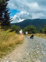
This portion of the hike takes you down through meadows and high-elevation Spruce-Fir and Northern Hardwood forests. You'll croass a clear, cold, babbling stream just before entering the clearing at Camp Alice, your first destination on the hike. Camp Alice is a historic logging camp and tourist railroad depot. From there, tourists would climb to the summit of Mount Mitchell to enjoy the views from the East's highest mountain.
The road to Camp Alice is maintained for occasional use by park trucks accessing the water station located there, and the surface is mostly smooth pea-sized to 2-inch gravel. It also roughly parallels a power line right-of-way, so you'll see those occasionally. With the road, power lines, and views of the buildings along the ridge, this isn't a wilderness hike, but parts of it can still feel secluded and serene - a lot more so than the summit area trails, at least.
Some areas can get soggy after it rains, but there are no major streams to cross. Shortly after starting the hike you'll wrap around the east side of an unnamed mountain. Here the forest is mixed, with spruces, firs, and high-elevation hardwoods in disturbed areas. Next, you'll go around Bearwallow and Grassy Knob Ridges.

The forest opens up, and spruces and firs grow along the edges of grassy and fern-filled meadows. This slope is directly below the park's restaurant. According to one source at the park, that building was originally meant to be a ski lodge. The slopes you're looking at were to be the ski slopes. Although the skiing would've been great at this high altitude, park officials never figured out how they intended to get vehicles up to the lodge in the snow, so plans for a ski resort were scrapped and the lodge was turned into the present-day restaurant.
Continue past the grassy slopes and you'll dip into the Lower Creek valley, right below Mount Mitchell's summit. The forest transitions briefly to almost all northern hardwoods just past Grassy Knob Ridge before filling back in with spruces and firs as you approach Lower Creek, and Camp Alice. Ahead of you, as you come under the power lines again, you'll catch great views up to the summit of Mount Mitchell, down into the Lower Creek valley and its grassy meadows, and of the surrounding mountains as well.
Just before you reach Lower Creek is an intersection with another trail, at some rock steps on the left. This is the Camp Alice trail. It's also co-signed as the N.C. Mountains to Sea Trail. The Mountains to Sea trail is a new trail, and it was routed along existing trails and roads wherever possible, so many older trails are similarly co-signed. It comes in from your right further along (where it is co-signed as the Buncombe Horse Range Trail) and exits to the left here on a steep climb to the summit. Continue straight.
The old railroad bed you've been following crosses Lower Creek. Then the service road exits to the left and goes up to the park's water station. This is Camp Alice, and it's a place with a very unique feeling across the southern Appalachian Mountains - like a "bald" on the side of the mountain rather than the top, where balds are most common. If you're turning around here, be sure to spend some time enjoying the scenery, maybe pick some blueberries or explore the small cascades on Lower Creek, before returning the way you came.
Part 2: to Commissary Hill (3.6 miles round-trip from start)
You can turn around here or go on to Commissary Ridge, which is 0.7 miles further ahead. Just continue straight to get there.
On the left, past where the service road cuts left, is a large, round, concrete well. Although the trail becomes a bit rockier, wetter, and grown in with grass and shrubs beyond Camp Alice, it still has a gentle slope since it's still the old railroad grade. You'll exit the State Park and travel onto Pisgah National Forest property. There is a sign at the boundary, but all you'll see is the back of it so it's easy to miss. It doesn't matter - just keep going straight.
Shortly after that, you'll reach another intersection. This is where the Mountains to Sea Trail and the Buncombe Horse Range Trail come in from the right, on another railroad grade which they share. Continue straight; our railroad grade is now named the Buncombe Horse Range Trail. From here to the campsite the scenery is more of the same and it is one of my favorite stretches of easy hiking in the state. There are some rock outcrops beside the trail, and tall spruces and firs fill back in in the forested margins of the road.

Before long you'll reach the wide open, grassy campsite on your right - a flat spot on Commissary Ridge called Commissary Hill. This marks the official end of the hike. Relax under the shade of a spruce tree or explore carefully around the huge rocks. You can also see the foundation of the old trail shelter, long since removed. From wherever you decide to turn around, just follow the railroad grade back up to the park office. Remember: it's slightly uphill on the way back (a 300 ft climb from Lower Creek), so keep that in mind when judging your energy level!
Beyond Commissary Hill

The railroad grade makes a left turn here around Commissary Ridge. If you were to continue hiking on it, just past the campsite you would reach an intersection with the Mount Mitchell and Mountains to Sea Trails on the left as they come down Commissary Ridge from the summit. A brief stretch of the old grade beyond that is shared by 3 trails: the Buncombe Horse Range, Mount Mitchell, and the Mountains to Sea Trails.
Then, the Mountains to Sea and Mount Mitchell trails exit to the right and descend 3000 ft. in elevation to the Black Mountain Campground on a difficult path. That leaves the railroad grade named just the Buncombe Horse Range Trail. It continues on that way for several more miles, going around Mount Mitchell and Mount Craig on a level route to Maple Camp Bald, before finally descending into the Toe River valley further north. Honestly, you might want to look at a map to make sense of it, but it's obvious this railroad grade is a useful path, since nearly every trail at Mount Mitchell follows it at some point!
All Photos from This Hike


Map
Green highlight indicates the route to follow within the trail network for this hike.
Tip: Printing this map? You can pan and zoom the map as desired before printing to show the area you need.
Map Information
Download GPS Data
Click on a route, trail, or point on the map and select the GPS Data tab to download its data.
Data Formats
KML (Google Earth)
KML is the main file type used by Google Earth. If you have Google Earth installed, clicking the KML link should open the trail or point directly in Google Earth for viewing. This is the native file format used by Google Earth, but many other map applications can use and understand KML as well, so if you're not sure which one to download, KML is a good bet.
GPX
The GPX format stands for GPS Exchange - a free, open, XML format for exchanging GPS and map data. GPX is compatible with Google Earth, many other mapping programs, and most GPS devices (such as Garmin). Load the file directly into your GPS to help find your way on your next trip!
GeoJSON
GeoJSON is a newer, lightweight data exchange format which can be used to quickly share map data and may have a smaller size than KML or GPX. Many professional mapping and GIS applications support the GeoJSON format.
About the Map
Copyright
Base Layers
Base layers provided by OpenStreetMap, the US Geological Survey, the US Forest Service, and NC OneMap. Base layer images are subject to the respective copyright policies of their owners. Base layers may not be available at all times due to system maintenance or outages.
WNCOutdoors Base Layer
The WNCOutdoors Base layer is provided by WNCOutdoors.info. It is licensed by Creative Commons Attribution 3.0.
Trail and Marker Overlays
Trail layers and downloadable data are all original works created by WNCOutdoors with guidance from a variety of sources, including ensembles of our own GPS tracks, user contributed GPS tracks, official maps and GIS data from government agencies, and field observations. WNCOutdoors data is made freely available under the Open Database License - you are free to copy and use it for any purpose under the terms of that license (summary).
Tips
- Hover over a trail to see it highlighted. Helps to see start and end points for an individual trail.
- Scroll and zoom the map before printing, and that view will persist into the printed image.
- Click a trail for more details and to download it individually.
Feedback
Ratings
Average Rating: 2.7 (rated 6 times)
Rate It Now:

[Site Admin] Jordan M. said: You're right, thanks! We've updated the description :)
Pipsissewa said: One error: Under "Beyond Commissary Hill, you write, "Then, the BUNCOMBE HORSE RANGE and Mount Mitchell trails exit to the right and descend 3000 ft. in elevation to the Black Mountain Campground on a difficult path." It SHOULD say, "Then, the MOUNTAINS TO SEA and Mount Mitchell trails exit to the right and descend 3000 ft. in elevation to the Black Mountain Campground on a difficult path. Other than that, great description!