Hiking in Montreat, North Carolina
Montreat is the name of a town, college, and Presbyterian conference center located in a cove at the foot of the Black Mountains, near the Blue Ridge. The word "Montreat" is a portmanteau of Mountain Retreat, reflecting the vision the developers of the property had for this scenic location. All of Montreat is meticulously cared for and a highly enjoyable place to spend some time outdoors.


Overview
Areas Open to Hiking
Though most of the trails in Montreat traverse private property (owned by the conference center), it is generously open to individual hikers provided a simple set of rules are followed (see Rules & Regulations below). Some trails wind through neighborhoods or across parcels of town property, or can be connected via neighborhood roads, sidewalks, and greenway paths. Please be on your best behavior while visiting here to ensure access to the area for everyone in the future! See Hiking Trails below.
Topography
Part of what makes hiking in Montreat appealing is the rugged topography of the area, a deep basin carved out of the Black Mountains with steep ridges on either side. Montreat sits in the Flat Creek valley north and slightly east of Black Mountain, NC, which is named for the Black Mountains range, which loom above Montreat to the north.
A ridge coming southwest from the Black Mountains, with prominent peaks including Pinnacle, Rocky Knob, Graybeard Mountain, and Middle Mountain forms the west-side ridge. This ridge, which marks the border with the Asheville watershed, contains the well-known Seven Sisters Peaks, visible from many points in town.
The east side ridge marks the Eastern Continental Divide, and includes iconic peaks such as Rainbow Mountain and Lookout Mountain. It's a historic route into the Black Mountains from the Swannanoa River valley to the south, with evidence of an old railroad and toll vehicle road carved into its steep slopes.
Elevations range from about 2500 ft near the historic stone entrance gate on NC Hwy 9 to over 5400 ft on Graybeard Mountain, which results in high overall precipitation, a wide variety of elevation-dependent climates, and high biodiversity. Much of the area is protected as wilderness via a conservation easement. Neighborhoods are carved out of the wilderness near the bottom of the valley, putting some of the hikes in the urban-wildland interface zone.
Hiking Trails
The Montreat trail network contains a number of routes ranging from easy to quite difficult, in environments ranging from suburban to quasi-wilderness. The majority of the trails are on property owned by Mountain Retreat Association, both within and outside the conservation area. Some trails cross briefly onto neighboring Pisgah National Forest, and the Old Mitchell Toll Road continues onto private property north of Montreat to connect to the Blue Ridge Parkway. Public access to that route is generally allowed only in the warm season.

Easy Trails
Gate Trail


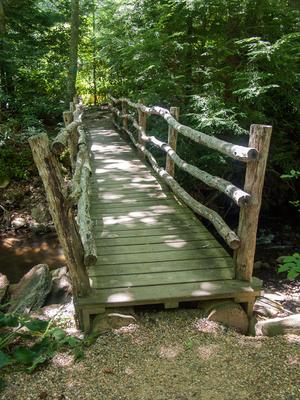
At the bottom of the valley, the Gate trail starts at the main entrance gate and follows a gentle path through neighborhoods in the woods beside Flat Creek. It crosses tributaries on bridges, skirts recreation facilities and culminates on a gravel path through Robert Lake Park. Just ahead is the Nature Center, Lake Susan and more parking. You can hike this path out-and-back or return via the sidewalks and greenway paths along the main entrance road.
At the Graybeard trailhead, you can combine the lower portion of the Graybeard trail, the Harry Bryan trail, and the Julia Woodward and Sanctuary trails into a nice, relatively easy loop. This route includes stream-side forest scenes, bridges, a small waterfall on a tributary stream, rock outcrops, and nice forest areas just outside a Montreat neighborhood. The loop ends in Walk Jones Wildlife Sanctuary with a small pond for quiet relaxation.
Moderate Trails
The Lower Piney trail makes an excellent, moderate out-and-back hike along a rocky mountainside with a view of the town. The Lookout trail climbs steeply, but is mercifully short as it culminates atop Lookout Mountain on Montreat's eastern ridge with a spectacular view back to the west of Graybeard Mountain, the Seven Sisters ridge, and Black Mountain beyond. Climb Rainbow Road instead of the Lookout trail to make this into a longer loop with a less-steep initial climb. Or loop north via East Ridge, Buck Gap, and Old Trestle Road trails as another option.
More Difficult Trails
Graybeard Mountain Hike

The Graybeard trail climbs over 2400 ft on a 4.5 mile course (so at least 9 miles round-trip) from its trailhead on Flat Creek to the summit of Graybeard Mountain, with stops at Graybeard Falls and Walker's Knob along the way. This is probably the most popular difficult hike in Montreat, and it's one of the Best Hikes on this site.
Montreat's West Ridge trail can be hiked alone, or as part of a climb up to Graybeard, and is one of the more remote and challenging trails in the area. You'll reach it via one of two other challenging trails, Stomping Knob or Big Piney Ridge. These can be combined with the Graybeard trail to make an excellent, challenging loop.
Rainbow Mountain and Rocky Head trails climb the east ridge of the valley and meet up with the well-named East Ridge trails.
Parallel to, but not nearly as rough and steep as, East Ridge trail are the Old Mitchell Toll Road and the Old Trestle Road. The two latter trails are difficult because of their length, but not nearly as difficult from a terrain perspective due to their history as old automobile and train routes, respectively. These reach into Pisgah National Forest, then private property, and eventually meet up with the Blue Ridge Parkway miles north of Montreat.
Old Mitchell Toll Road is closed during bear hunting season.
This is just an overview of the trails in Montreat. For the complete list with all the details, visit the Montreat Trail List page. For what we consider to be the best hikes that use these trails, see the Montreat Hikes page.

History
In the late 1800's, the first 4500 acres of land for what would become known as Montreat were purchased by a group of clergy and lay leaders in the Flat Creek valley northeast of Black Mountain. 4000 acres passed hands to the Mountain Retreat Association, which still holds title to the land today, in the early 1900's. Construction of the buildings and infrastructure continued through the middle of the century, including the round-roofed Anderson Auditorium in 1922 and the concrete dam at Lake Susan in 1924. In 1934, Montreat College assumed its final name.
Moving toward mid-century, by 1967, The Town of Montreat was incorporated. The retreat became officially affiliated with the Presbyterian Church in 1983. And in 2004, 2,460 acres of land was placed under a conservation easement to permanently protect the Montreat Wilderness from development. Much of the area used by hikers today is on the land covered by this conservation easement.
Rules & Regulations

Since this is private property, hikers need to follow all posted rules to ensure future access to the trail system.
- Individual private hikers are welcome.
- If you're visiting with a group or organization (other than your family), you're required to check in with Montreat Conference Center ahead of time before hiking.
- Stay on marked trails. Hikers use the trail system at their own risk.
- No bicycles, except on Rainbow Road and Appalachian Way (to reach the Old Mitchell Toll Road).
- No motor vehicles of any kind.
- No horses.
- No flagging or marking routes.
- The area is a Wildlife and Natural Resource Preserve. No harvesting/collecting plants, animals, or minerals.
- Dogs must be leashed at all times.
- Camping is not allowed except at designated shelter sites. Check with Montreat Conference Center before considering camping.
Click here for more information and an updated trail map (May 2019 PDF).
Directions
To the Montreat Gate
From Asheville, take I-40 East about 11 miles to Black Mountain, exit 64 for NC Hwy. 9. Turn left at the end of the ramp and go 0.5 mi into downtown Black Mountain. Continue on NC 9 across State St. (it's a slight left through the intersection) and go 1.7 mi to the stone arch gate at Montreat. The road's name changes to Assembly Drive at the gate.
Gate Trailhead
Parking for the Gate Trail, Rainbow Mountain Trail, and is at the gravel drive on the right just past the gate. This is also the parking area for the memorial gardens.
Anderson Parking Lot
From the Montreat gate, go 0.9 mi on Assembly Drive to Community Center Circle and turn right. This larger parking area is immediately on the left. This is the other end of the Gate trail (through Robert Lake Park), and provides access to the Nature Center, Montreat Store, and Lake Susan. There's some more parking streetside on Assembly Drive just beyond Lookout Road beside Lake Susan if this lot is full.
Lookout Trailhead
From the Montreat gate, go 0.9 mi on Assembly Drive to Lookout Rd and turn right. Go straight at the 4-way stop, staying on Lookout Rd. Go 0.5 mi to the trailhead on the right. There are two main parking areas and a few pull-off spots beside the road. Do not block gates, drive off-road or violate "no parking" areas. This parking area can fill up on popular hiking days.
Graybeard Trailhead
From the Montreat gate, go 1.1 mi on Assembly Drive, past Lake Susan. Assembly Drive curves right; go straight/slight left onto Graybeard Trail. It's 0.8 mi to the parking area, on the right at the Walk Jones Wildlife Sanctuary where the road turns to gravel. The trailhead is just ahead on the right.
Contact Information
Montreat Conference Center
401 Assembly Drive
Montreat, NC 28757
828-669-2911
800-572-2257
Web Site
