Wildcat Rock Trail

At A Glance


3.9 mi one-way
Difficulty Rating: 8.35 ![]()
Steepness: Climbs Steeply ![]()
Tread Condition: Moderately Rough ![]()
Lowest Elevation: 2365 ft
Highest Elevation: 4232 ft
Climb Total: 2100 ft
Blaze Color: Red-orange
Description
Note: The trail is now officially open all the way to Bearwallow Mountain! GPS recordings and our GIS data show the hike to be just under 4 miles one-way, excluding the short out-and-backs along the way (to wildcat rock, through the pastures, etc). Official descriptions say 5 miles one-way or 10 miles round-trip, which is a safe bet if you go up to Wildcat Rock or leave the trail at all for exploring.
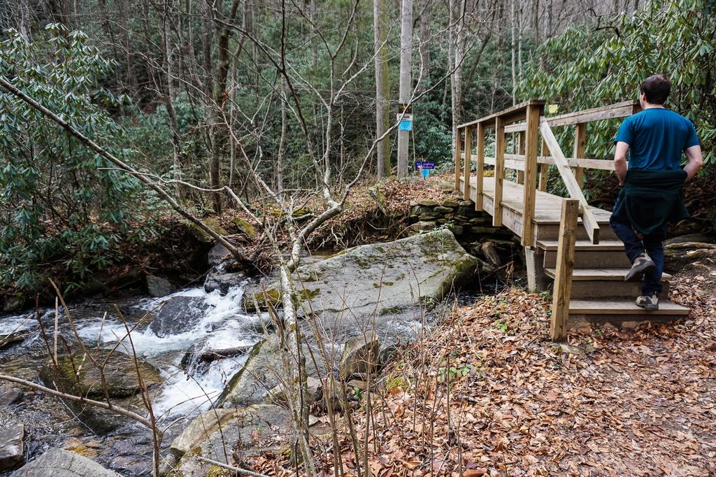
This (for the most part) newly-constructed trail climbs the side of Little Bearwallow Mountain in the upper Hickory Nut Gorge, then climbs up Bearwallow Montain. Passing over private property, it starts as a walk skirting the edge of an orchard (follow the signed route and please stay on the trail). It descends to a crossing of Hickory Creek on a sturdy bridge.

Though the main flow of the creek is bridged, a side channel requires a rock-hop before you reach the bridge. This one can be tricky in high water, or with kids. If the water is too high to safely cross, you may have to turn back!
On the other side of the creek, the trail turns downstream for a short distance, swings right in a patch of doghobble, and then starts decidedly uphill on a well-constructed, newly-built segment of trail. The trail has log and rock steps in places, but is generally well groomed and free of major obstacles. The trail passes through a mixed hardwood forest with an understory of less-common (in the mountains) Carolina rhododendron, rhododendron minus, in places.
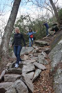
As it ascends, the trail clings to a steep mountainside before rock-hopping a small tributary - the same one the waterfall is on upstream. Look uphill in winter when the leaves are off the trees for a glimpse of it. It then passes through a series of switchbacks before entering a boulder field. The boulders, and a set of rock steps, are signs that you that you're nearing the base of the falls.
Remember, this is private property. Stay on the trail and don't try to access the waterfall by going straight up the mountain like some folks have been seen doing. The trail comes out at a rocky area below the cliff over which the tiny stream flows - maybe no more than a trickle or seep during dry periods - to form the falls.

From the base of the falls, the trail swings right, ascending along the base of the rock face. You'll pass over an outcrop with a great view back down toward the falls, before passing under an overhang, where the trail levels out somewhat. It ascends and descends slightly over a rough course along the cliff base, then begins an ascent toward Wildcat Rock. A spur trail on the left climbs to the top of the rock, with panoramic 180 degree views of the upper Hickory Nut Gorge area.
As of November 2020, the trail extension from Wildcat Rock to Bearwallow Mountain is complete! The trail continues its climb up past Wildcat Rock, entering the pastures near the saddle between Little Bearwallow and Bearwallow mountains. It then swings toward the summit of Bearwallow, which it reaches after a few switchback sections.
Intersecting Trails
This trail is located in the Hickory Nut Gorge area. For a list of all the trails in that area, see the Hickory Nut Gorge trails list page.
This trail also crosses into these trailhead areas:
- Alexander Mountain Bike Park (Trail List)
- Bearwallow Mountain (Trail List)
- Florence Nature Preserve (Trail List)
All Photos from the Trail


GPS Map
Map Information
Download GPS Data
Click on a route, trail, or point on the map and select the GPS Data tab to download its data.
Data Formats
KML (Google Earth)
KML is the main file type used by Google Earth. If you have Google Earth installed, clicking the KML link should open the trail or point directly in Google Earth for viewing. This is the native file format used by Google Earth, but many other map applications can use and understand KML as well, so if you're not sure which one to download, KML is a good bet.
GPX
The GPX format stands for GPS Exchange - a free, open, XML format for exchanging GPS and map data. GPX is compatible with Google Earth, many other mapping programs, and most GPS devices (such as Garmin). Load the file directly into your GPS to help find your way on your next trip!
GeoJSON
GeoJSON is a newer, lightweight data exchange format which can be used to quickly share map data and may have a smaller size than KML or GPX. Many professional mapping and GIS applications support the GeoJSON format.
About the Map
Copyright
Base Layers
Base layers provided by OpenStreetMap, the US Geological Survey, the US Forest Service, and NC OneMap. Base layer images are subject to the respective copyright policies of their owners. Base layers may not be available at all times due to system maintenance or outages.
WNCOutdoors Base Layer
The WNCOutdoors Base layer is provided by WNCOutdoors.info. It is licensed by Creative Commons Attribution 3.0.
Trail and Marker Overlays
Trail layers and downloadable data are all original works created by WNCOutdoors with guidance from a variety of sources, including ensembles of our own GPS tracks, user contributed GPS tracks, official maps and GIS data from government agencies, and field observations. WNCOutdoors data is made freely available under the Open Database License - you are free to copy and use it for any purpose under the terms of that license (summary).
Tips
- Hover over a trail to see it highlighted. Helps to see start and end points for an individual trail.
- Scroll and zoom the map before printing, and that view will persist into the printed image.
- Click a trail for more details and to download it individually.
Trail Segments
Trails are often made up of several connecting paths which may have different characteristics, allowed uses, and seasons. This trail is divided into multiple segments as follows:
Wildcat Rock - Parking to Little Bearwallow Falls
- Allowed Uses: Hiking
- Length: 1.07 mi
Wildcat Rock - Lower Bearwallow Falls to Wildcat Rock Spur
- Allowed Uses: Hiking
- Length: 0.43 mi
Wildcat Rock - Spur to Rock
- Allowed Uses: Hiking
- Length: 248 ft
Wildcat Rock - Rock Spur to Little Bearwallow Ridgeline
- Allowed Uses: Hiking
- Length: 1.06 mi
Wildcat Rock - Little Bearwallow Ridge to Bearwallow Summit
- Allowed Uses: Hiking
- Length: 1.43 mi
Total Calculated Length: 4.04 mi
This value is derived from our underlying map data, and it may not match officially published information.
Feedback
Ratings
Average Rating: 3.5 (rated 2 times)
Rate It Now:

[Site Admin] Jordan M. said: @Vince - we've updated the description, stats, and map to include the newly extended trail!
Vince said: The trail is considerably longer than 1.1 miles now. It goes on past the waterfall and continues climbing. Look for the trail running off the main run, taking you out to Wildcat Rock overlook, for a spectacular view. This is about 2 miles up the trail, and is well worth the moderately difficult climb.