Jack Branch Trail

At A Glance


2.4 mi one-way
Difficulty Rating: 2.4 ![]()
Steepness: Climbs Moderately ![]()
Tread Condition: Some Obstacles ![]()
Blaze Color: Blue
Trail Number: 299
Description
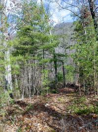
Starting at the tip of the River Ridge Loop trail, Jack Branch climbs along an old road bed in places, while in others it slips away to amble along the ridge. The forest burned in the early 2000s in this area, giving it an open feeling except where it has filled back in thickly with Virginia and Shortleaf pines. Follows the ridge between Jack and Murray Branches, but spends more time over on the Murray side. Has some limited wintertime views.
Joins with FS 468 and follows it for a bit before splitting off to the right to finish the climb up to the state line ridge and FS 422 in Cherokee National Forest.
Intersecting Trails
This trail is located in the Hot Springs area. For a list of all the trails in that area, see the Hot Springs trails list page.
All Photos from the Trail


GPS Map
Map Information
Download GPS Data
Click on a route, trail, or point on the map and select the GPS Data tab to download its data.
Data Formats
KML (Google Earth)
KML is the main file type used by Google Earth. If you have Google Earth installed, clicking the KML link should open the trail or point directly in Google Earth for viewing. This is the native file format used by Google Earth, but many other map applications can use and understand KML as well, so if you're not sure which one to download, KML is a good bet.
GPX
The GPX format stands for GPS Exchange - a free, open, XML format for exchanging GPS and map data. GPX is compatible with Google Earth, many other mapping programs, and most GPS devices (such as Garmin). Load the file directly into your GPS to help find your way on your next trip!
GeoJSON
GeoJSON is a newer, lightweight data exchange format which can be used to quickly share map data and may have a smaller size than KML or GPX. Many professional mapping and GIS applications support the GeoJSON format.
About the Map
Copyright
Base Layers
Base layers provided by OpenStreetMap, the US Geological Survey, the US Forest Service, and NC OneMap. Base layer images are subject to the respective copyright policies of their owners. Base layers may not be available at all times due to system maintenance or outages.
WNCOutdoors Base Layer
The WNCOutdoors Base layer is provided by WNCOutdoors.info. It is licensed by Creative Commons Attribution 3.0.
Trail and Marker Overlays
Trail layers and downloadable data are all original works created by WNCOutdoors with guidance from a variety of sources, including ensembles of our own GPS tracks, user contributed GPS tracks, official maps and GIS data from government agencies, and field observations. WNCOutdoors data is made freely available under the Open Database License - you are free to copy and use it for any purpose under the terms of that license (summary).
Tips
- Hover over a trail to see it highlighted. Helps to see start and end points for an individual trail.
- Scroll and zoom the map before printing, and that view will persist into the printed image.
- Click a trail for more details and to download it individually.
Trail Segments
Trails are often made up of several connecting paths which may have different characteristics, allowed uses, and seasons. This trail is divided into multiple segments as follows:
Jack Branch - Start to River Ridge Loop
- Allowed Uses: Hiking
- Length: 0.26 mi
Jack Branch - River Ridge Loop Interior
- Allowed Uses: Hiking
- Length: 0.36 mi
Jack Branch - River Ridge Loop to FS 468
- Allowed Uses: Hiking
- Length: 1.79 mi
Jack Branch - FS 468 to FS 422
- Allowed Uses: Hiking
- Length: 0.95 mi
Total Calculated Length: 3.35 mi
This value is derived from our underlying map data, and it may not match officially published information.
Feedback
Ratings
Average Rating: (rated 0 times)
Rate It Now:

Alexana Wolf said: I tried to go here yesterday but it was completely grown over. It didn't look like anyone had been there in a while...The river ridge loop was somewhat overgrown but passable. I couldn't get more than 30 feet onto the Jack Branch trail before it was too thick and I turned around.