High Falls Trail

At A Glance


0.7 mi one-way
Difficulty Rating: 1.91 ![]()
Steepness: Climbs Steeply ![]()
Tread Condition: Some Obstacles ![]()
Lowest Elevation: 2875 ft
Highest Elevation: 3510 ft
Climb Total: 650 ft
Blaze Color: None
Hikes That Use This Trail: Tuckasegee High Falls
Description
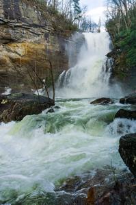
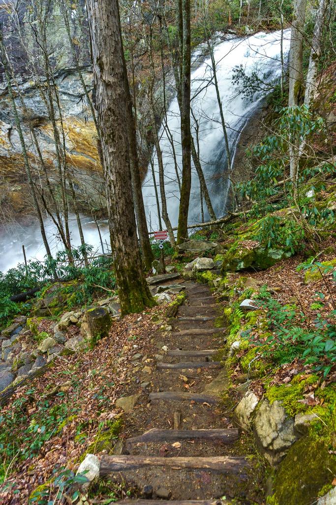
From the parking area away from the lake, the trail begins as a gated road leading down below part of the dam. It winds downhill on a graveled path to a hairpin turn near a drainage basin, then turns right at a sign. From there the trail becomes much steeper and descends sets of log steps toward the river, which it begins following downstream. The trail will cross a couple of unique, small bridges and then descend steeply on rock steps. Only short stretches are actual dirt trail. You'll see how much work was required to build this trail - hundreds of massive logs and stones (sourced from on-site) were put into place to keep hikers safely on the path. The trail passes by an upper waterfall, called First Falls, and then under a neat overhanging cliff as you go past the brink of High Falls. The trail then descends on rock steps through switchbacks beside the upper part of High Falls to reach the put-in at its base.
Note: Though this trail is 0.7 mi in length, there's no connections, so there's no option but to hike it out-and-back for a total distance of 1.4 mi. This trail constitutes the Tuckasegee High Falls Hike. For more details, see the hike page.
Directions
From the I-40 and I-26 interchange in Asheville, NC, take I-40 west about 18 miles to Exit 27 for the Great Smoky Mountains Expressway, US 74/19/23 toward Waynesville. Follow the expressway for about 21 miles to Exit 85 for Sylva/Cullowhee. Follow Business 23 for about 1.8 miles into town and turn left on NC 107. Go just over 20 miles on 107 (past Western Carolina University) and turn right onto Pine Creek Road. It's 2 miles on this crooked road to The Pines Recreation Area, just across the dam, where there is parking on both sides of the road for the trail.
This trail is located in the Pines Recreation Area area. For a list of all the trails in that area, see the Pines Recreation Area trails list page.
All Photos from the Trail


GPS Map
Map Information
Download GPS Data
Click on a route, trail, or point on the map and select the GPS Data tab to download its data.
Data Formats
KML (Google Earth)
KML is the main file type used by Google Earth. If you have Google Earth installed, clicking the KML link should open the trail or point directly in Google Earth for viewing. This is the native file format used by Google Earth, but many other map applications can use and understand KML as well, so if you're not sure which one to download, KML is a good bet.
GPX
The GPX format stands for GPS Exchange - a free, open, XML format for exchanging GPS and map data. GPX is compatible with Google Earth, many other mapping programs, and most GPS devices (such as Garmin). Load the file directly into your GPS to help find your way on your next trip!
GeoJSON
GeoJSON is a newer, lightweight data exchange format which can be used to quickly share map data and may have a smaller size than KML or GPX. Many professional mapping and GIS applications support the GeoJSON format.
About the Map
Copyright
Base Layers
Base layers provided by OpenStreetMap, the US Geological Survey, the US Forest Service, and NC OneMap. Base layer images are subject to the respective copyright policies of their owners. Base layers may not be available at all times due to system maintenance or outages.
WNCOutdoors Base Layer
The WNCOutdoors Base layer is provided by WNCOutdoors.info. It is licensed by Creative Commons Attribution 3.0.
Trail and Marker Overlays
Trail layers and downloadable data are all original works created by WNCOutdoors with guidance from a variety of sources, including ensembles of our own GPS tracks, user contributed GPS tracks, official maps and GIS data from government agencies, and field observations. WNCOutdoors data is made freely available under the Open Database License - you are free to copy and use it for any purpose under the terms of that license (summary).
Tips
- Hover over a trail to see it highlighted. Helps to see start and end points for an individual trail.
- Scroll and zoom the map before printing, and that view will persist into the printed image.
- Click a trail for more details and to download it individually.
Feedback
Ratings
Average Rating: (rated 0 times)
Rate It Now:

No comments yet.