Rainbow Mountain Trail

At A Glance


0.7 mi one-way
Difficulty Rating: 2.31 ![]()
Steepness: Climbs Moderately ![]()
Tread Condition: Moderately Rough ![]()
Lowest Elevation: 2500 ft
Highest Elevation: 3320 ft
Climb Total: 820 ft
Blaze Color: Gray
Description
Starts across Flat Creek from the Montreat gate; use the bridge for the Gate trail to access the trailhead. Turn right onto the gravel road once across the bridge, then turn left at the maintenance area to start the tail. The trailhead is signed.
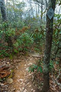
The trail starts out on a gentle grade but then veers left up the ridge. It's very steep in places. The trail has some rocky and rooty spots so watch your footing. It winds through a series of switchbacks as it climbs some rather steep sections with steps and footholds. It passes a few limited, mainly wintertime views.
The forest on this ridge is mostly scraggly oaks with a few evergreens such as white pine and Carolina hemlock. The trail passes over one of the two peaks of Rainbow Mountain, marked by a small angled rock outcrop, before dropping back down slightly to meet up with Rainbow Road.
Intersecting Trails
This trail is located in the Montreat area. For a list of all the trails in that area, see the Montreat trails list page.
All Photos from the Trail


GPS Map
Map Information
Download GPS Data
Click on a route, trail, or point on the map and select the GPS Data tab to download its data.
Data Formats
KML (Google Earth)
KML is the main file type used by Google Earth. If you have Google Earth installed, clicking the KML link should open the trail or point directly in Google Earth for viewing. This is the native file format used by Google Earth, but many other map applications can use and understand KML as well, so if you're not sure which one to download, KML is a good bet.
GPX
The GPX format stands for GPS Exchange - a free, open, XML format for exchanging GPS and map data. GPX is compatible with Google Earth, many other mapping programs, and most GPS devices (such as Garmin). Load the file directly into your GPS to help find your way on your next trip!
GeoJSON
GeoJSON is a newer, lightweight data exchange format which can be used to quickly share map data and may have a smaller size than KML or GPX. Many professional mapping and GIS applications support the GeoJSON format.
About the Map
Copyright
Base Layers
Base layers provided by OpenStreetMap, the US Geological Survey, the US Forest Service, and NC OneMap. Base layer images are subject to the respective copyright policies of their owners. Base layers may not be available at all times due to system maintenance or outages.
WNCOutdoors Base Layer
The WNCOutdoors Base layer is provided by WNCOutdoors.info. It is licensed by Creative Commons Attribution 3.0.
Trail and Marker Overlays
Trail layers and downloadable data are all original works created by WNCOutdoors with guidance from a variety of sources, including ensembles of our own GPS tracks, user contributed GPS tracks, official maps and GIS data from government agencies, and field observations. WNCOutdoors data is made freely available under the Open Database License - you are free to copy and use it for any purpose under the terms of that license (summary).
Tips
- Hover over a trail to see it highlighted. Helps to see start and end points for an individual trail.
- Scroll and zoom the map before printing, and that view will persist into the printed image.
- Click a trail for more details and to download it individually.
Trail Segments
Trails are often made up of several connecting paths which may have different characteristics, allowed uses, and seasons. This trail is divided into multiple segments as follows:
Rainbow Mountain - Gate to Traverse
- Allowed Uses: Hiking
- Length: 0.44 mi
Rainbow Mountain - Traverse to Rainbow Road
- Allowed Uses: Hiking
- Length: 0.27 mi
Total Calculated Length: 0.71 mi
This value is derived from our underlying map data, and it may not match officially published information.
Feedback
Ratings
Average Rating: (rated 0 times)
Rate It Now:

No comments yet.