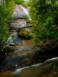
Wilderness Falls Trail

At A Glance


0.73 mi one-way
Difficulty Rating: 1.21 ![]()
Steepness: Climbs Moderately ![]()
Tread Condition: Few Obstacles ![]()
Lowest Elevation: 3725 ft
Highest Elevation: 3990 ft
Climb Total: 265 ft
Trail Number: 490
Hikes That Use This Trail: Panthertown Valley Tour
Description
Starting just west of Salt Rock along the Panthertown Valley trail, this trail descends on a path with three distinct characters, past the base of Wilderness Falls. The upper portion is not recommended until a re-route of the middle section is completed. This re-route is officially proposed by the Forest Service as of July 2012.
The portion from the Panthertown Valley trail to the top of the falls is on an old road bed and is in generally good shape with moderate grades, with only a few eroded spots. Closer to the top of the falls, it's mostly level and in great shape.
The section from the top of the falls to the bottom is narrow, slippery, steep, and rough. This is the section that will be by-passed with a reroute. It comes out on a rock outcrop (the same one that forms the falls), and descends steeply alongside the waterfall to its base, directly down-slope. It's not great at all.
The portion from the Deep Gap trail to the base of the falls is in decent shape again, though - narrow and twisty in spots, with a few mud sections, but nothing terrible and no major climbs.
Thus, if you're just wanting to see the falls, come in from the bottom (Cold Mtn. Trail) and skip the middle part, until it gets re-routed. It's well worth it.
Intersecting Trails
This trail is located in the Panthertown Valley area. For a list of all the trails in that area, see the Panthertown Valley trails list page.
All Photos from the Trail

GPS Map
Map Information
Download GPS Data
Click on a route, trail, or point on the map and select the GPS Data tab to download its data.
Data Formats
KML (Google Earth)
KML is the main file type used by Google Earth. If you have Google Earth installed, clicking the KML link should open the trail or point directly in Google Earth for viewing. This is the native file format used by Google Earth, but many other map applications can use and understand KML as well, so if you're not sure which one to download, KML is a good bet.
GPX
The GPX format stands for GPS Exchange - a free, open, XML format for exchanging GPS and map data. GPX is compatible with Google Earth, many other mapping programs, and most GPS devices (such as Garmin). Load the file directly into your GPS to help find your way on your next trip!
GeoJSON
GeoJSON is a newer, lightweight data exchange format which can be used to quickly share map data and may have a smaller size than KML or GPX. Many professional mapping and GIS applications support the GeoJSON format.
About the Map
Copyright
Base Layers
Base layers provided by OpenStreetMap, the US Geological Survey, the US Forest Service, and NC OneMap. Base layer images are subject to the respective copyright policies of their owners. Base layers may not be available at all times due to system maintenance or outages.
WNCOutdoors Base Layer
The WNCOutdoors Base layer is provided by WNCOutdoors.info. It is licensed by Creative Commons Attribution 3.0.
Trail and Marker Overlays
Trail layers and downloadable data are all original works created by WNCOutdoors with guidance from a variety of sources, including ensembles of our own GPS tracks, user contributed GPS tracks, official maps and GIS data from government agencies, and field observations. WNCOutdoors data is made freely available under the Open Database License - you are free to copy and use it for any purpose under the terms of that license (summary).
Tips
- Hover over a trail to see it highlighted. Helps to see start and end points for an individual trail.
- Scroll and zoom the map before printing, and that view will persist into the printed image.
- Click a trail for more details and to download it individually.
Trail Segments
Trails are often made up of several connecting paths which may have different characteristics, allowed uses, and seasons. This trail is divided into multiple segments as follows:
Wilderness Falls - Above Falls
- Allowed Uses: Hiking
- Length: 0.47 mi
Wilderness Falls - Below Falls
- Allowed Uses: Hiking
- Length: 0.3 mi
Total Calculated Length: 0.77 mi
This value is derived from our underlying map data, and it may not match officially published information.
Feedback
Ratings
Average Rating: (rated 0 times)
Rate It Now:

No comments yet.