South Mills River Trail

At A Glance


12 mi one-way
Difficulty Rating: 12 ![]()
Steepness: Climbs Gently ![]()
Tread Condition: Moderately Rough ![]()
Blaze Color: White
Trail Number: 133
Description
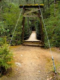
This is a stream side trail along an old road bed for much of its length; pulls away from the river along one section around High Falls. Crosses the river using bridges (concrete and suspension bridges) and fords it many times as well. There are some very muddy, overgrown, and sandy sections, especially between the intersection of Cantrell Creek and Squirrel Gap trails. Heavy horse usage. Scenic, wide river as it drops out of the Pink Beds. There were once many dense, open groves of hemlock along stretches of this trail; these are mostly dead, and almost all of the large, old, stout hemlocks growing beside the river are dead and falling into it.
Intersecting Trails
This trail is located in the Mills River area. For a list of all the trails in that area, see the Mills River trails list page.
All Photos from the Trail


GPS Map
Map Information
Download GPS Data
Click on a route, trail, or point on the map and select the GPS Data tab to download its data.
Data Formats
KML (Google Earth)
KML is the main file type used by Google Earth. If you have Google Earth installed, clicking the KML link should open the trail or point directly in Google Earth for viewing. This is the native file format used by Google Earth, but many other map applications can use and understand KML as well, so if you're not sure which one to download, KML is a good bet.
GPX
The GPX format stands for GPS Exchange - a free, open, XML format for exchanging GPS and map data. GPX is compatible with Google Earth, many other mapping programs, and most GPS devices (such as Garmin). Load the file directly into your GPS to help find your way on your next trip!
GeoJSON
GeoJSON is a newer, lightweight data exchange format which can be used to quickly share map data and may have a smaller size than KML or GPX. Many professional mapping and GIS applications support the GeoJSON format.
About the Map
Copyright
Base Layers
Base layers provided by OpenStreetMap, the US Geological Survey, the US Forest Service, and NC OneMap. Base layer images are subject to the respective copyright policies of their owners. Base layers may not be available at all times due to system maintenance or outages.
WNCOutdoors Base Layer
The WNCOutdoors Base layer is provided by WNCOutdoors.info. It is licensed by Creative Commons Attribution 3.0.
Trail and Marker Overlays
Trail layers and downloadable data are all original works created by WNCOutdoors with guidance from a variety of sources, including ensembles of our own GPS tracks, user contributed GPS tracks, official maps and GIS data from government agencies, and field observations. WNCOutdoors data is made freely available under the Open Database License - you are free to copy and use it for any purpose under the terms of that license (summary).
Tips
- Hover over a trail to see it highlighted. Helps to see start and end points for an individual trail.
- Scroll and zoom the map before printing, and that view will persist into the printed image.
- Click a trail for more details and to download it individually.
Trail Segments
Trails are often made up of several connecting paths which may have different characteristics, allowed uses, and seasons. This trail is divided into multiple segments as follows:
South Mills River - Turkeypen TH to Bridge
- Allowed Uses: Hiking, Mountain Biking, Horseback Riding
- Length: 0.43 mi
South Mills River - Turkeypen Connector to Bridge
- Allowed Uses: Hiking, Mountain Biking, Horseback Riding
- Length: 379 ft
South Mills River - Turkeypen Bridge
- Allowed Uses: Hiking, Mountain Biking, Horseback Riding
- Length: 256 ft
South Mills River - Turkeypen Bridge to Mullinax
- Allowed Uses: Hiking, Mountain Biking, Horseback Riding
- Length: 0.25 mi
South Mills River - Mullinax to Poundingmill
- Allowed Uses: Hiking, Mountain Biking, Horseback Riding
- Length: 1.23 mi
South Mills River - Poundingmill to Wagon Road Gap
- Allowed Uses: Hiking, Mountain Biking, Horseback Riding
- Length: 1.14 mi
South Mills River - Wagon Road Gap to Cantrell Creek
- Allowed Uses: Hiking, Mountain Biking, Horseback Riding
- Length: 0.88 mi
South Mills River - Cantrell Creek to Squirrel Gap
- Allowed Uses: Hiking, Mountain Biking, Horseback Riding
- Length: 4.93 mi
South Mills River - Wolf Ford - Squirrel to High Falls
- Allowed Uses: Hiking, Mountain Biking, Horseback Riding
- Length: 525 ft
South Mills River - High Falls to Buckhorn Gap
- Allowed Uses: Hiking, Mountain Biking, Horseback Riding
- Length: 2.67 mi
South Mills River - Buckhorn Gap to High Falls
- Allowed Uses: Hiking, Mountain Biking, Horseback Riding
- Length: 0.94 mi
South Mills River - High Falls to FS 476
- Allowed Uses: Hiking, Mountain Biking, Horseback Riding
- Length: 0.99 mi
Total Calculated Length: 13.67 mi
This value is derived from our underlying map data, and it may not match officially published information.
Feedback
Ratings
Average Rating: 4.1 (rated 8 times)
Rate It Now:

SL said: Just got back from a 2.5 day trip that included most of the South Mills River trail. Camped the first night at WF-6 by the gate at the far end of Wolf Ford Rd (turns off of Yellow Gap Road at the horse camp). The hike from there to Wolf Ford and the Squirrel Gap Trail intersection was easy to follow and the trail was in great shape. No blazes, but no chance to get on a wrong trail either. One note here: we used the Pisgah Map Company trail maps. The map shows you can cross the swinging bridge at Wolf Ford and take a right through the camp sites to continue on South Mills River trail. Absolutely not the case. Don't cross the bridge. Instead, stay straight and it'll take you to the first wet crossing. From here to Cantrell Creek it's a different story. Zero blazes, mud pits every few hundred feet, tremendous trail overgrowth. Nothing you can't handle, but the brambles hanging at shin level beat your legs to death for 5 miles. No damage done, but sure got annoying. There was a section where some cutting had been done for maintenance, but it wasn't much. Also in this section, there were a couple of spots where we followed the trail per the map, then came to a dead end due to deadfalls after a few feet. A short backtrack showed a river crossing, looks like the trail was rerouted since our map was made (even though it's the newest map) to get around the deadfalls. Anyhow, not much harm done since it was never more than a one-minute backtrack. There was a cool log and rock structure about halfway through this section of trail across the river. We didn't check it out, but would love to know the story behind it. Not sure if it was something built for hikers, for maintenance crews, or something else. Kinda neat to come across it. Huge tree down across the river right at the crossing to it, so that's a good marker if you want to find it. Speaking of wet crossings, check your water levels as others have said. Water levels ranged from shin deep to top of thigh deep (I'm 5' 10"). They were almost all very rocky- and not small, easy to walk rocks. I'm talking small boulders in the water that could wreak havoc on an ankle or leg. It was interesting with a full pack to say the least. Take your time and you'll be OK. But pick another time if it's the rainy season. This section of trail looks barely used, so if you get hurt nobody is going to happen by to help you. Be smart and don't do this section alone just to be safe. Once we hit Cantrell Creek, all was good again. Well marked and easy to follow, plenty of campsites. We turned north on Pounding Mill, so didn't walk the last couple of miles of South Mills River to the Turkey Pen parking area, but I suspect nothing tricky on that section (we were in the Turkey Pen/Bradley creek area just two weeks ago and all looked good). All in all a great hike- even the middle section as long as you know what to expect. Between Squirrel Gap and Cantrell Creek, you'll likely have perfect solitude.
Kenneth Foret said: We just finished our hike (early April '18) and we took the south mills river trail out of turkey pen parking lot. I was with my three children ages 13-16. The trail is great up to Cantrell Creek trail with a few suspension bridge crossings and wide trail. A few mountain bikers and a couple of other hikers made the trail very peaceful. Great campsites along this section of trail and there are not a ton of blazes and the white can sometimes be hard to see with moss on the trees. But we found the trail very easy to follow. If you continue on like we did to Squire Gap trail be prepared for quite a few stream crossings (about 10). Since it was early April I suspect the flow was much more than in summer but it was challenging to cross at a couple of sites. I'm 6'2" and one crossing the water was high up on my thighs. It added a lot of time to the trip and the water was very cold. The trail in this section is also a lot narrower, single track, with low over growth impinging on the trail. Not sure what kind of undergrowth it was, it didn't hurt much, but was very annoying. The trail is still very easy to follow but was much longer then I thought from the map. If I had it to do over I definitely would have skipped this part of the trail.
JC said: I highly recommend this trail for a daytrip or overnight! Easy hike with lots of beautiful sites. Runs along the river with great campsites all over.
gjm said: Just got back from 3 days on this trail, and I have to say, it is an extremely beautiful hike! We didn't experience any navigational difficulty, blazes are few and far between, luckily all the side trails are marked well. We turned back at the crossing just before the intersection of squirrel gap, the water was up quite a bit and there was no crossing with packs! Make sure you are aware of the water levels before attempting this trail, I can't wait to hit it again in the summer.
JLS said: had a similar experience as JLO. Set out to do an easy 3-day loop around South Mills & Squirrel Gap. First took a wrong turn which ended up being a shortcut over a ridge-top from just before the trail meets the Buckhorn Gap trail to just before it meets the Squirrel Gap Trail. Could not for the life of us figure out where the trail continues after the junction with Squirrel Gap (about 5 miles in), but there are 2 really nice campsites on the river there and 2 others within the first 5 miles. The part of the trail we were on WAS lovely - nice and wide in most places with an easy grade. No vistas but nice valley scenery. Looks like a lot of great places to swim in the summer. A nice hike if you come in with the right expectations, I guess. If I came back I'd just plan to spend one night at a riverside campsite.
JLO said: This would probably be a nice trail if there were blazes because then you could figure out where you were supposed to be going. There were plenty of extra trails not shown on the map, and we ended up taking the wrong turns and had to backtrack quite a ways several times when we hit dead ends on what looked like the right path. I am a very experienced hiker and map reader and have never had problems like this before. It got very frustrating backpacking with a child. The campsites that we found were really nice though, at least we had a positive experience with that. We ran into two other groups that had their maps out also that were having the same problem trying to find the trail as we were. After three days of trying to figure out where we were supposed to be going, we gave up and hiked back to our car. On a side note, make sure you bring shoes that can get wet, we ended up switching between our boots and sandals quite often with the fords which became very time consuming.