Art Loeb Section 3 Trail

At A Glance


6.8 mi one-way
Difficulty Rating: 6.8 ![]()
Steepness: Hilly ![]()
Tread Condition: Moderately Rough ![]()
Blaze Color: White
Description
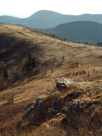
Starting at Black Balsam Road and going generally north, this is one of the most popular stretches of the Art Loeb trail as it crosses over the 6,214 ft summit of Black Balsam Knob. It then winds along the side of the ridge before crossing the summit of Tennent Mountain. Spectacular views exist in all directions from the summits along this stretch of trail.
The trail then descends toward Ivestor Gap, where the number of hikers drops dramatically, putting it into the mere "heavily used" category. It becomes heavily overgrown and dramatically eroded along this stretch as well. It briefly meets up with the Ivestor Gap trail at the gap before angling right across the Shining Rock Wilderness boundary.
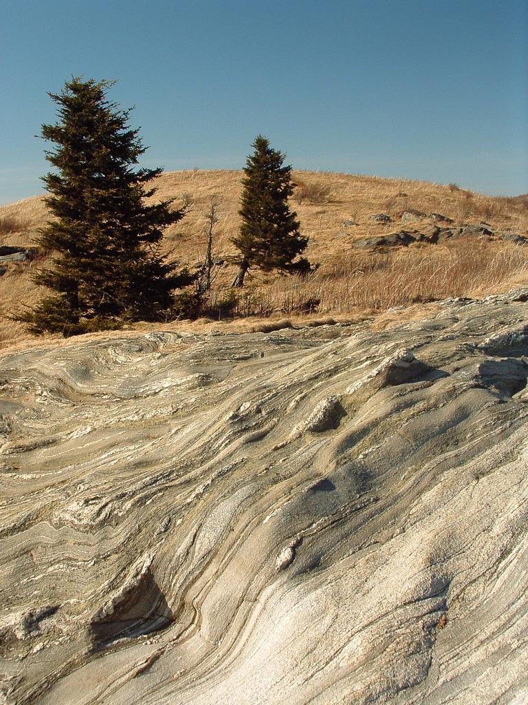
The trail climbs around Grassy Cove Top on another overgrown, neglected stretch of path, descends to Flower Gap, then traverses an old road into Shining Rock Gap, where there are some reliable springs. It angles left through the gap at junctions with the Shining Creek, Old Butt Knob, and Ivestor Gap trails, then follows Shining Rock Ledge west of Shining Rock itself - the quartzite rock outcrop which gives this wilderness area its name. It continues along the ledge at or above 5000 ft in elevation all the way to Deep Gap, where an out-and-back extension climbs up to the summit of Cold Mountain.
Intersecting Trails
This trail is located in the Shining Rock Wilderness area. For a list of all the trails in that area, see the Shining Rock Wilderness trails list page.
This trail also crosses into these trailhead areas:
All Photos from the Trail


GPS Map
Map Information
Download GPS Data
Click on a route, trail, or point on the map and select the GPS Data tab to download its data.
Data Formats
KML (Google Earth)
KML is the main file type used by Google Earth. If you have Google Earth installed, clicking the KML link should open the trail or point directly in Google Earth for viewing. This is the native file format used by Google Earth, but many other map applications can use and understand KML as well, so if you're not sure which one to download, KML is a good bet.
GPX
The GPX format stands for GPS Exchange - a free, open, XML format for exchanging GPS and map data. GPX is compatible with Google Earth, many other mapping programs, and most GPS devices (such as Garmin). Load the file directly into your GPS to help find your way on your next trip!
GeoJSON
GeoJSON is a newer, lightweight data exchange format which can be used to quickly share map data and may have a smaller size than KML or GPX. Many professional mapping and GIS applications support the GeoJSON format.
About the Map
Copyright
Base Layers
Base layers provided by OpenStreetMap, the US Geological Survey, the US Forest Service, and NC OneMap. Base layer images are subject to the respective copyright policies of their owners. Base layers may not be available at all times due to system maintenance or outages.
WNCOutdoors Base Layer
The WNCOutdoors Base layer is provided by WNCOutdoors.info. It is licensed by Creative Commons Attribution 3.0.
Trail and Marker Overlays
Trail layers and downloadable data are all original works created by WNCOutdoors with guidance from a variety of sources, including ensembles of our own GPS tracks, user contributed GPS tracks, official maps and GIS data from government agencies, and field observations. WNCOutdoors data is made freely available under the Open Database License - you are free to copy and use it for any purpose under the terms of that license (summary).
Tips
- Hover over a trail to see it highlighted. Helps to see start and end points for an individual trail.
- Scroll and zoom the map before printing, and that view will persist into the printed image.
- Click a trail for more details and to download it individually.
Trail Segments
Trails are often made up of several connecting paths which may have different characteristics, allowed uses, and seasons. This trail is divided into multiple segments as follows:
Mountains to Sea Trail - Art Loeb - Black Balsam Road to Split
- Allowed Uses: Hiking
- Length: 73 ft
Art Loeb Section 3 - MST Split to Black Balsam Spur
- Allowed Uses: Hiking
- Length: 0.43 mi
Art Loeb Section 3 - Black Balsam Spur to Summit Bypass
- Allowed Uses: Hiking
- Length: 0.15 mi
Art Loeb Section 3 - Black Balsam Summit Bypass
- Allowed Uses: Hiking
- Length: 0.12 mi
Art Loeb Section 3 - Black Balsam Summit Ridge
- Allowed Uses: Hiking
- Length: 0.13 mi
Art Loeb Section 3 - Black Balsam Summit Ridge Bypass
- Allowed Uses: Hiking
- Length: 0.41 mi
Art Loeb Section 3 - Black Balsam Switchback
- Allowed Uses: Hiking
- Length: 0.3 mi
Art Loeb Section 3 - Black Balsam Switchback to Tennent Connector
- Allowed Uses: Hiking
- Length: 66 ft
Art Loeb Section 3 - Tennent Connector to Ivestor Gap Shared
- Allowed Uses: Hiking
- Length: 0.94 mi
Ivestor Gap - Art Loeb Shared N. of Tennent
- Allowed Uses: Hiking
- Length: 153 ft
Art Loeb Section 3 - Ivestor Gap Shared to Ivestor Gap
- Allowed Uses: Hiking
- Length: 0.35 mi
Art Loeb Section 3 - Thru Ivestor Gap
- Allowed Uses: Hiking
- Length: 97 ft
Art Loeb Section 3 - Ivestor Gap to Shining Creek
- Allowed Uses: Hiking
- Length: 1.76 mi
Art Loeb Section 3 - Shining Creek to Shining Rock Gap
- Allowed Uses: Hiking
- Length: 239 ft
Art Loeb Section 3 - Thru Shining Rock Gap
- Allowed Uses: Hiking
- Length: 52 ft
Art Loeb Section 3 - Shining Rock Gap to Cold Mountain
- Allowed Uses: Hiking
- Length: 2.76 mi
Total Calculated Length: 7.47 mi
This value is derived from our underlying map data, and it may not match officially published information.
Feedback
Ratings
Average Rating: 4.3 (rated 3 times)
Rate It Now:

Patrick said: Very popular in the warmer months. It is easy to get off course when you approach Shining Rock, There are several spurs off this section that go to campsites and overlooks. Bring a map and compass, or GPS if your headed to Cold Mountain. Love this area!