Greasy Cove Trail

At A Glance


3.2 mi one-way
Difficulty Rating: 3.2 ![]()
Steepness: Climbs Steeply ![]()
Tread Condition: Moderately Rough ![]()
Blaze Color: None
Trail Number: 362
Description
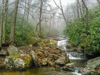
This trail initially traverses Grassy Cove Ridge at or near its crest, with minimal views other than of the Parkway, until it drops down to Greasy Cove Prong. Caution: The trail is especially difficult to see during this descent. It follows the prong until that stream meets the East Fork of the Pigeon River, where the trail terminates at the junction of the Big East Fork (#357) and Bridges Camp Gap (#607) trails.
Intersecting Trails
This trail is located in the Shining Rock Wilderness area. For a list of all the trails in that area, see the Shining Rock Wilderness trails list page.
This trail also crosses into these trailhead areas:
All Photos from the Trail

GPS Map
Map Information
Download GPS Data
Click on a route, trail, or point on the map and select the GPS Data tab to download its data.
Data Formats
KML (Google Earth)
KML is the main file type used by Google Earth. If you have Google Earth installed, clicking the KML link should open the trail or point directly in Google Earth for viewing. This is the native file format used by Google Earth, but many other map applications can use and understand KML as well, so if you're not sure which one to download, KML is a good bet.
GPX
The GPX format stands for GPS Exchange - a free, open, XML format for exchanging GPS and map data. GPX is compatible with Google Earth, many other mapping programs, and most GPS devices (such as Garmin). Load the file directly into your GPS to help find your way on your next trip!
GeoJSON
GeoJSON is a newer, lightweight data exchange format which can be used to quickly share map data and may have a smaller size than KML or GPX. Many professional mapping and GIS applications support the GeoJSON format.
About the Map
Copyright
Base Layers
Base layers provided by OpenStreetMap, the US Geological Survey, the US Forest Service, and NC OneMap. Base layer images are subject to the respective copyright policies of their owners. Base layers may not be available at all times due to system maintenance or outages.
WNCOutdoors Base Layer
The WNCOutdoors Base layer is provided by WNCOutdoors.info. It is licensed by Creative Commons Attribution 3.0.
Trail and Marker Overlays
Trail layers and downloadable data are all original works created by WNCOutdoors with guidance from a variety of sources, including ensembles of our own GPS tracks, user contributed GPS tracks, official maps and GIS data from government agencies, and field observations. WNCOutdoors data is made freely available under the Open Database License - you are free to copy and use it for any purpose under the terms of that license (summary).
Tips
- Hover over a trail to see it highlighted. Helps to see start and end points for an individual trail.
- Scroll and zoom the map before printing, and that view will persist into the printed image.
- Click a trail for more details and to download it individually.
Feedback
Ratings
Average Rating: 4.0 (rated 1 times)
Rate It Now:

Jon Baatz said: I will be hiking up Bridges Camp Gap Trail and this trail heading back to the Art Loeb. Do you know if there is a good selection of campsites to fit a couple hammocks? Thanks for any information you can give. Jon
Patrick said: There is a section of this trail where you have to cross the creek. If you do not cross the creek, you will end up at Graveyard Fields via Bridges Camp Gap.