Hiking in the Curtis Creek Area
Curtis Creek is a major tributary of the upper Catawba River, draining the southeast slope of the Blue Ridge not far from the town of Old Fort, NC. Its valley is home to some large swaths of Pisgah National Forest lands, and several trails and notable landmarks are accessible to hikers within the valley.


In addition to the natural scenery, the area has a historic interest as well. It includes the first tract of eastern forest acquired through the Weeks Act in 1911.
For the purposes of this site, we include areas between Iron Mountain in the southwest, US 70 in the southeast, Mackey Mountain in the northeast, and the Blue Ridge Parkway in the northwest, including the Newberry Creek and Mackey Creek drainages adjacent to Curtis Creek.
Hiking Trails
Until recently, the Curtis Creek area was largely underdeveloped as far as trails were concerned, with large areas off the main road managed as backcountry and some of the older trails fading into obscurity.
New Trails on the National Forests ⁉
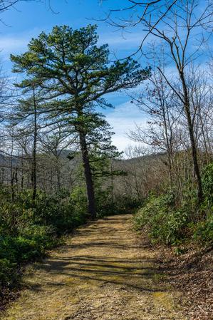
That changed considerably in June 2022 when the first phase of the Old Fort Gateway Trails opened, with 6 miles of newly-constructed trails completed out of a planned 40+ mile expansion of the Grandfather Ranger District's trail network. Located near the entrance to the Curtis Creek area, the trails are easily accessible from Old Fort and have quickly become quite popular.

Combined with Jarrett Creek Road, this "stacked loop" trail system provides an optimal experience for mountain bikers, but the trails are also open to hiking.
Look for the trailhead sign 1.5 miles west of US 70 on Curtis Creek Road.
Oldies But Goodies
A few other, older hiking-only trails can be found farther up the Curtis Creek and Newberry Creek valleys. Except for the stretch of trail leading to Hickory Branch Falls, and to a lesser extent Snook's Nose, the trails are very lightly used and maintain a backcountry character. Some areas may require backcountry navigation skills to traverse, and some trails aren't blazed or maintained for years at a stretch.
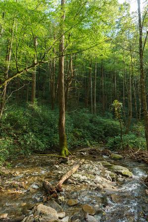
Several waterfalls lie along the area's streams, and trails climb the ridges over 3000 ft vertical to span the entire elevation range of the Blue Ridge in this area. Trails at the edges of the area connect to others making longer, multi-day trips that start or end in Curtis Creek a possibility as well.

Hickory Branch Trail


The Hickory Branch trail starts at the Curtis Creek Campground and goes up and over a ridge into the Hickory Branch drainage, then heads upstream. It passes the waterfall on Hickory Branch and continues on up to a trail on the ridge line.
This ridgeline trail, called Lead Mine Gap, connects from the end of Hickory Branch trail across Buckeye Knob back to Curtis Creek Road to the north. This section is fairly well maintained. The portion that used to head east down to the middle of Mackey Creek is now closed and unmaintained.
Just up Curtis Creek Road from the north end of Lead Mine Gap, the infamous Mackey Mountain trail starts and heads southeast. This trail begins well enough, winding along and across the ridgeline past Sams Knob and over to Narrows Knob, but it fades away as it goes. The trail becomes all but indistinct before essentially petering out in several directions once reaching Mackey Mountain itself.
There are no maintained connections toward the southern end of Mackey Mountain trail, even though the trail officially connects back to lower Mackey Creek road. But there are several potential connections you could make back east down to Mackey Creek (by following the old route, if you can found it), south to Stillhouse Branch, or north to Locust Creek via old, abandoned routes.
Everything past Narrows Knob on the Mackey Mountain trail should be considered wilderness travel.
Also starting at the same location on Curtis Creek Road as the Mackey Mountain trail is the Sugar Cove trail (#213), an now-closed old road leading down into Sugar Cove and FS 1188.

Another trail, Snook's Nose, starts at the Curtis Creek Campground and climbs steeply past Slick Falls to its namesake - a rock outcrop on the ridge 1600 vertical feet above the campground. This is a highly recommended hike if you're up to the climb. It then continues north uphill along the ridge across Laurel Knob and on up to the Green Knob overlook on the Blue Ridge Parkway some 1200 ft higher still. Unlike Mackey Mountain and Lead Mine Gap, this trail is maintained, blazed, and easy to follow.

Licklog Hike

From the overlook, the Parkway's Green Knob trail climbs past the lookout tower and connects to trails in the Black Mountains/South Toe River area for longer hike options.
An unmarked trail (which I haven't field-checked) reportedly leads down into the Newberry Creek drainage from near the north end of Snook's Nose trail, expanding the long-distance hiking opportunities into the Star Gap and Heartbreak Ridge areas near Old Fort for intrepid multi-day backpacking trips.
Some other closed, gated Forest Service roads exist in the area which make great hiking opportunities as well. The old Sugar Cove Road is one of them. Another old road, Licklog Road (FS 482B) near the upper end of the Curtis Creek drainage just off the Blue Ridge Parkway is such a great route that it's one of the Best Easy Hikes in the region!
This is just an overview of the hiking trails in the area. For a list of all trails, see the Curtis Creek Trails page.
Map
Map Information
Download GPS Data
Click on a route, trail, or point on the map and select the GPS Data tab to download its data.
Data Formats
KML (Google Earth)
KML is the main file type used by Google Earth. If you have Google Earth installed, clicking the KML link should open the trail or point directly in Google Earth for viewing. This is the native file format used by Google Earth, but many other map applications can use and understand KML as well, so if you're not sure which one to download, KML is a good bet.
GPX
The GPX format stands for GPS Exchange - a free, open, XML format for exchanging GPS and map data. GPX is compatible with Google Earth, many other mapping programs, and most GPS devices (such as Garmin). Load the file directly into your GPS to help find your way on your next trip!
GeoJSON
GeoJSON is a newer, lightweight data exchange format which can be used to quickly share map data and may have a smaller size than KML or GPX. Many professional mapping and GIS applications support the GeoJSON format.
About the Map
Copyright
Base Layers
Base layers provided by OpenStreetMap, the US Geological Survey, the US Forest Service, and NC OneMap. Base layer images are subject to the respective copyright policies of their owners. Base layers may not be available at all times due to system maintenance or outages.
WNCOutdoors Base Layer
The WNCOutdoors Base layer is provided by WNCOutdoors.info. It is licensed by Creative Commons Attribution 3.0.
Trail and Marker Overlays
Trail layers and downloadable data are all original works created by WNCOutdoors with guidance from a variety of sources, including ensembles of our own GPS tracks, user contributed GPS tracks, official maps and GIS data from government agencies, and field observations. WNCOutdoors data is made freely available under the Open Database License - you are free to copy and use it for any purpose under the terms of that license (summary).
Tips
- Hover over a trail to see it highlighted. Helps to see start and end points for an individual trail.
- Scroll and zoom the map before printing, and that view will persist into the printed image.
- Click a trail for more details and to download it individually.
Facilities
The Curtis Creek Campground is at the junction of Curtis Creek and Hickory Branch at the valley's bottom, along the main road through the area, Curtis Creek Road. It features three loops with 25 sites, some of which are rather spread out and perfect for tent camping. The campground has vault toilets and hand-pump water, and there are no hookups for RV's. All sites include a tent pad, picnic table, lantern post, and fire ring. It is generally open April - December.
A hiker parking area with a few picnic tables is also available by Curtis Creek near the upper part of the campground.
More lodging options are available in the towns of Old Fort, Black Mountain, and Marion (from closest to farthest).
