Mount Mitchell Hike

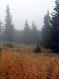
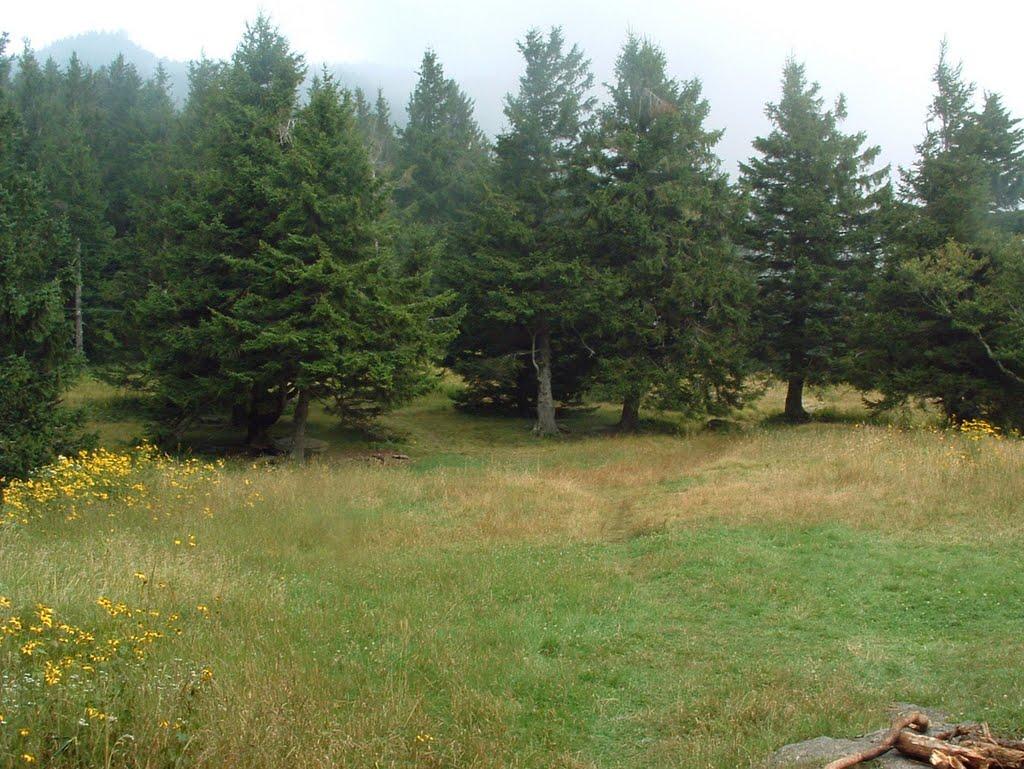
Starting at the Black Mountain Campground on the Toe River, this hike gains 3600 ft in elevation over 5 1/2 miles to reach the summit of the East's highest peak, making it one of the toughest continuous climbs in the region, near the limit of what most people will want to tackle in a day hike. You'll enjoy a varied forest that changes with the elevation. Much of the forest is old-growth, changing from cove hardwoods at the lower end, to mixed hardwoods on the middle ridges, to Red Spruce and Fraser Fir stands near the summit. And, of course, there are spectacular views from high up.
At A Glance
 11.4 mi round-trip
Difficulty Rating: 19.9 ![]()
Tread Condition: Moderately Rough ![]()
Climb: Climbs Steeply ![]()
Lowest Elevation: 2995 ft
Highest Elevation: 6684 ft
Climb Total: 3689 ft
Configuration: Out-and-back
Starting Point: Black Mountain Campground (or optionally Mount Mitchell State Park summit parking area)
Trails Used: Mount Mitchell, Balsam Nature, Summit, Buncombe Horse Range, Briar Bottom, Mountains to Sea Section 3, Higgins Bald, River Loop
Hike Start Location
Directions
From Asheville, take I-240 East to I-40 East toward Old Fort, N.C., about 19 miles. Take exit 72 for US Hwy. 70 East and go thru downtown Old Fort. Turn left on NC Hwy. 80 9.6 miles after exiting I-40. Go just under 14 1/2 miles, up the Blue Ridge and past the Parkway, and then turn left onto S. Toe River Road. (Continued below)
From points north, take US 19 W through Burnsville, NC. A little over 3 miles past NC Hwy. 197 in Burnsville, turn right on NC Hwy. 80, and follow it about 9 miles to the Mount Mitchell Golf Course. Turn right on S. Toe River Road just past the golf course; there are signs for the Black Mountain Campground.
(Continued from above) From NC 80 and S. Toe River Road, it is about 2.5 miles to the Black Mountain Campground, following the signs. Bear right after 1.9 miles at a triangular intersection. The day hiking parking area is just before the bridge to the campground, on the left. If the campground is closed, the parking area will still be open - you can walk through the campground to the trail.
Details
Hike Description
Mount Mitchell is the highest peak east of the Mississippi river at 6,684' in elevation. While there are much easier ways to reach the top, part of the appeal of this hike is the experience of "summiting" this superior peak. This hike qualifies as an accepted route for the South Beyond 6000 Program by the Carolina Mountain Club, which recognizes members who climb all 40 peaks above 6000' in the Southern Appalachians.

This hike has developed somewhat of a legend around its difficulty, partly because Mt. Mitchell is the highest peak in the region. Although that's the case, the campground sits at a respectable elevation of 3000 ft. itself, meaning the difference from the base to top isn't as high as it could be. The trail does have one of the highest elevation changes of any single-name trail in the region at 3600 ft., and it's got its fair share of roots, rocks, and rough sections. But there are harder trails (or hikes combining multiple trails) in the region as well.
Ultimately, how difficult you find it to hike, and how long it will take you, will depend greatly on your fitness and level of experience (just read the comments on this page!), but to be safe, it should be considered quite difficult unless you're certain that you're up to it.
It's very doable as a day hike, although some people choose to do the trail over 2 days, spending the night near the top. Allow a full day with plenty of time to spare if it's your first trip.
You could also start at the top and hike down, but if you don't have a vehicle shuttle you'll have to hike back up anyway. One good option to lessen the strain, but still make for quite an achievement, would be to leave a vehicle shuttle at the summit parking area and hike up, then avoid the impact on the knees by driving back down.
This hike's description assumes you're starting at the bottom going up. Although several other named trails share the path you'll be taking, you can just follow the blue-blazed Mount Mitchell trail the entire route.
Begin the hike by crossing the bridge leading into the campground. Bear left at the first intersection onto a campground loop road; from here, follow the signs for the Mount Mitchell trail all the way to the top. The easy Briar Bottom/Mount Mitchell trail angles left off the campground loop road and winds up by the S. Toe River. Follow it for a few yards to the intersection on the right with the Mount Mitchell trail, going back across the gravel road.

Now on the Mt. Mitchell trail proper, the climbing immediately begins in earnest. At this elevation, the forest is mostly cove hardwoods with a few hemlocks thrown in for good measure, though they are dead or dying. You will ascend through a small cove, whose stream is gradually eating its way into Long Arm Ridge. Toward the back of the cove you'll bear right through the first of many switchbacks encountered along the way. The trail at the start here heads generally north, though at any given moment you my be facing any of the cardinal directions due to the way it switches back upon itself. The trail climbs up the side of Long Arm Ridge.
Some very large trees grow in the forest here, and as you gain elevation on the ridgeline you enter a mixed oak hardwood forest. A few small Red Spruce trees grow here, although they're out-of-place at this low of an elevation and will likely be shaded out before reaching maturity. The footing on this section of the trail is mostly good, with only a few rocky or rooty sections.
After achieving the top of Long Arm Ridge, the trail turns west and ascends its spine, swinging back and forth across it in places. You'll break past the 4000 ft. elevation mark on this section of trail. The trees along the ridgeline - predominantly oaks and maples - are now shorter. They're stunted compared to the ones lower down by this area's exposure; the shallow, rocky soil; and lack of water as these steep slopes drain quickly. Some rougher sections of trail start to appear, although it's still the climb more than the surface that makes it challenging.
You'll reach a trail junction shortly and you can take either fork. Both trails come back together eventually; the left fork is called the Higgins Bald trail while straight ahead is the Mount Mitchell trail. You could also save the Higgins Bald trail and take it on the way back down, or skip it altogether.
East of the junction, the ridge sort of melts into a high, steep slope of "Little Mountain", which you'll traverse. The mountain won't seem very little as you climb it, though!
The Higgins Bald trail extends the hike by about 1/4 mile but takes you through the (formerly) scenic, eponymous heath bald. Climbing rapidly, the trail generally passes into the northern hardwood forest zone in this area. You'll cross the upper reaches of Setrock Creek, an easy rock-hop with as little flow as there is this high up the mountain. There are some cascades downhill from the trail, but they're not really worth expending effort to try and see.
Then you enter Higgins Bald itself. Roughly halfway to the top, this forest opening - which sits on a gentler slope above Flynn Ridge - lets you look down and see how far up you've come, and also look up to see how far you have left to go! (At least it used to have these views - it's apparently become too overgrown to see much in recent years, unfortunately. I'm holding out hope for a wintertime view remaining). Commissary Ridge looms above, which you'll soon begin to climb, and which culminates at the summit of Mount Mitchell itself. Lots of dead hemlocks stand in the forest encircling Higgins Bald.
You'll re-enter the forest on the other side of Higgins Bald, and then join back with the Mount Mitchell trail after a short distance; bear left (if you took Higgins Bald; continue straight if not).
The trail curves to a more northwesterly direction in general, just after crossing the 5000 ft. contour. You're now well into the spruce-fir forest zone. You'll walk through a spectacular virgin forest of tall, straight Red Spruce. Seeing them growing here gives you a glimpse of what forests all over the Black Mountain range used to look like, and a glimpse at why the forest was so valuable to loggers. The straight, resilient spruce wood was seemingly plentiful, so these trees were prize timber. Luckly, some patches such as this one survived, and other areas of spruce are starting to re-grow.
Sections of the trail in this area are very rocky and steep, and require some hand-holding to traverse. As you continue to climb through a series of switchbacks - and some of the steepest sections of trail on the hike - you'll cross under the power line right-of-way a few times, where there are some limited views.
Then you'll pop out of the forest onto the old railroad grade that encircles much of Mount Mitchell and provided a way for the loggers to get the fruits of their labor off the mountain. Turn left at this intersection, in a wet area (during periods of rain).
The path for the next few yards is shared with the Buncombe Horse Range Trail as it follows the railroad grade on a nearly level course, just shy of 5800 ft. elevation. You'll need to turn right off the railroad grade to stay on the Mt. Mitchell trail and begin the final 900 ft. climb up Commissary Ridge to the summit. The trail is well-signed and blazed so it shouldn't be hard to follow, unless perhaps if it's very foggy.
Just beyond that junction, the old railroad grade swings around toward the south side of the ridge. A great campsite is on the left at Commissary Hill in case you're looking for a place to spend the night. It is on Pisgah National Forest property, so backcountry and dispersed camping is allowed. (It is not allowed higher up, on NC State Park property, outside of the designated campground.)
This area receives much more precipitation than down at the Toe River, so the trail is a lot wetter up here in general, and everything is draped in lush, green moss. However, it can become bone dry during periods of drought since these steep, rocky slopes drain so quickly. Don't count on water beyond approximately the elevation of the railroad grade during dry spells.
The patch of forest as you start the climb up from the railroad grade on the Mt. Mitchell trail is mostly composed of imported Norway spruces. Native Red Spruce and Fraser Fir soon take back over the species list. You climb above the 6000 ft. contour not far beyond the second switchback past the railroad grade. The ridge in this area is pretty rugged, and you'll pass one nice, deep fracture cave on the way up through the switchbacks. Open glades with spruces all around give the area an alpine feeling.

You'll climb up onto the crest of the ridge after a relatively rough and eroded section of trail, and there, the forest becomes composed of almost pure Fraser Fir and some mountain ash. The trees get shorter near the top, attesting to their young age. These stands of Fir are ravaged by high winds, poor soil, and - within the last 50 years or so - a Balsam Wooly Adelgid insect infestation. 90% of the mature Firs are killed by the adelgids, which are related to the Hemlock Wooly Adelgids wiping out the hemlocks further down the mountain.
Luckily for the firs - and unlike the hemlocks - they are able to survive long enough to reproduce before the adelgids kill them, and large areas of lush, young firs still grow up here. Their ultimate survival remains to be seen in the face of pollution and climate change.
Once you reach a flatter section of trail with puncheon (sticks) laid across it to keep your feet out of the mud, you know you're getting close to the summit! You are on Mount Mitchell State park property now, having been on the National forest most of the route. (You may notice the sign welcoming you to the state park, but I didn't last time I hiked this.) Next, you'll reach the intersection with the Balsam Nature Trail, which leaves to the right. Continue straight ahead.
From that junction, the trail sees a good bit more use and you may share it with more adventurous tourists and their kids. You'll pass by an enormous, free-standing boulder on your right and a neat cave on the left. You never really get a view of the summit until you're right below it; at this point you're nearly done with the hike as you come out near a park building and a paved path. Turn left on the paved path and climb a few more feet to the summit.
So yes - I must admit that the last few yards of this hike are vastly different from the rest of it, since you've entered a developed tourist area. In fact, some people describe it as...well, a bit jarring! Or an underwhelming end to such a promising hike. That's understandable, since you've hiked through nearly 6 miles of wild lands up the East's highest mountain, only to now find yourself elbowing your way through hordes of tourists, who will be huffing and puffing their way slowly up the paved summit path. (Folks eating cheeseburgers from the concession stand will be sitting on resting benches found beside the path, or hitching a ride up in a golf cart from a park ranger).
Ok, that might be a bit of an exaggeration (they don't sell cheeseburgers at the concession stand)...but if you feel like a crowded summit might be a let down, just don't do this hike on a summer or early fall weekend. Try it on a "bad" weather day during the week (with proper gear, of course), or better yet when the Blue Ridge Parkway and State Park are closed. The trail remains accessible, yet you'll be all alone.

Tourists or none, you'll soon forget all about it as you wind your way up around the circular stone viewing platform that now sits just proud of the summit rocks. The views from up there are wonderful - and you'll want to take a well-earned rest to enjoy it before heading back down.
The deck of the platform is as high as you can get, east of the Mississippi. So enjoy your accomplishment, enjoy the view, grab a cheeseburger to eat and get ready - because you're half way done with the hike!
Return to your vehicle on the same trail. It will be a left at the railroad grade, then a right on the Mt. Mitchell trail on the way back as well. Be sure to take the other fork at Higgins Bald to enjoy the most variety on the hike!
All Photos from This Hike


Map
Green highlight indicates the route to follow within the trail network for this hike.
Tip: Printing this map? You can pan and zoom the map as desired before printing to show the area you need.
Map Information
Download GPS Data
Click on a route, trail, or point on the map and select the GPS Data tab to download its data.
Data Formats
KML (Google Earth)
KML is the main file type used by Google Earth. If you have Google Earth installed, clicking the KML link should open the trail or point directly in Google Earth for viewing. This is the native file format used by Google Earth, but many other map applications can use and understand KML as well, so if you're not sure which one to download, KML is a good bet.
GPX
The GPX format stands for GPS Exchange - a free, open, XML format for exchanging GPS and map data. GPX is compatible with Google Earth, many other mapping programs, and most GPS devices (such as Garmin). Load the file directly into your GPS to help find your way on your next trip!
GeoJSON
GeoJSON is a newer, lightweight data exchange format which can be used to quickly share map data and may have a smaller size than KML or GPX. Many professional mapping and GIS applications support the GeoJSON format.
About the Map
Copyright
Base Layers
Base layers provided by OpenStreetMap, the US Geological Survey, the US Forest Service, and NC OneMap. Base layer images are subject to the respective copyright policies of their owners. Base layers may not be available at all times due to system maintenance or outages.
WNCOutdoors Base Layer
The WNCOutdoors Base layer is provided by WNCOutdoors.info. It is licensed by Creative Commons Attribution 3.0.
Trail and Marker Overlays
Trail layers and downloadable data are all original works created by WNCOutdoors with guidance from a variety of sources, including ensembles of our own GPS tracks, user contributed GPS tracks, official maps and GIS data from government agencies, and field observations. WNCOutdoors data is made freely available under the Open Database License - you are free to copy and use it for any purpose under the terms of that license (summary).
Tips
- Hover over a trail to see it highlighted. Helps to see start and end points for an individual trail.
- Scroll and zoom the map before printing, and that view will persist into the printed image.
- Click a trail for more details and to download it individually.
Feedback
Ratings
Average Rating: 4.3 (rated 61 times)
Rate It Now:

Pierre said: Hike took 4 hours to get up, 3 to get down. The hikes not bad, its just very long and steep. If the view wasn't cloudy the reward would be better. This hike is good if your trying to challenge yourself. Be prepared to do nothing the next day if your out of shape. Everyone said to start early but I thought I could do better than everyone else's times so I started later around 12. I was wrong. Only had about 15 more minutes of daylight before I got to my car in time. This was with very short, not frequent, breaks.
Vanessa Vila said: I hiked this with my brother on Sunday 2/2/2020. We drove from Greensboro early that day. I was thankful for all the comments on this page, as I knew what to expect! We're both in good shape (ages 33, 34, and hike or trail run fairly often). For me, it was challenging, especially after the first few miles when we were hiking in SNOW. The trekking poles were VERY helpful in navigating all the snow and ice up top. Took us about 3 hours to go up, ate lunch near the top and took a break, then about 3 hours to get back down. Gorgeous views!! Was a full day of hiking and I was very tired afterwards, with sore legs. The next day we hiked Clingman's Dome, TN (even more snow there!) Not recommended for beginners, and will be a challenge even for intermediate hikers. We saw some folks who weren't carrying anything--or perhaps it was hidden in their coats. Meanwhile we had extra food, water, clothing, first aid, etc. just in case!
Scott said: Hiked the trail yesterday 10/5/2019 during cool, overcast conditions. The hike up took 2:45 from the parking lot across from the campground and 2:30 back down, both of which were faster than I expected. As a point of reference, I'm 55 and in pretty good cardio condition but don't do many hikes like this each year. The way up is strenuous but very manageable. I found the trip down to be worse than the trip up due to the large sections of the trail that are totally choked with roots and rocks. Makes for tedious hiking and puts a lot of stress on your ankles even in relatively dry conditions and with hiking poles (highly recommended). Hiking boots with strong ankle support and thick soles are also highly recommended. Not much to see on this hike, just thick forest. The path is very well blazed.
Jim FitzGerald said: I hiked this trail on Monday, October 15th, only saw one group on the way up (they rode to the top and hiked down) and two groups coming up as I went down. Trail was very wet with running water on the trail in several places, lots of slippery rocks and roots, I slipped and fell once cutting and scraping my right elbow with in the first couple of miles so I slowed down and was more careful to avoid wet rocks as much as possible. Took 3.5 hours to go up and almost the same to go down. There is not much scenic views to see on the way up due to tree canopy coverage but I highly recommend the trip. It is a good fitness hike and the view at the top is good. A lot of people who drove up were on the observation deck and some people on the upper trails reachable from the parking lot. I ran into four foreign tourists on the Buncombe horse trail section and they were looking to go back to the parking lot on a different route than the main Mitchel trail (1.6 mile) they had come down on . They asked about this route and I told them I did not know it and thought they should go back up the way they came to avoid getting lost. The two men got a bit angry at me and stomped off, I told the two women good luck if they want to find their route they had about 3 hours until dark. I have not heard of any lost tourists so I guess they made it out. I have two dogs that I hike a lot with, I would not take dogs on this trail if you intend to go the entire length.
Michelle Saleeby said: Can you bring dogs on this trail?
John Bradley said: Really great and helpful comments here. My wife and I hiked this trail on Saturday (August 4, 2018). We are fairly experienced hikers in good shape (I run as well), and we made it although we were a lot slower than we thought we'd be (4 hours going up, 3 hours coming down). I echo what everyone said, this is a tough trail with extremely difficult terrain. I cannot overestimate the difficulty posed by all the rocks and roots on this trail. Probably as difficult as any trail we've hiked in a long, long time. You really have to be careful where you place your feet at all times. The climbing starts as soon as you hit the trail and is relentless. And the downhill will eat your quads alive. Mine are still screaming today. Couple of things to pass along. POLES - I've just started using these, my wife has been using them for the past 5-6 years. They really, really saved me many times Saturday. I would have probably fallen on the way down 3 times had it not been for the poles. I am a firm believer in them now in general but especially for this hike. Footing was an issue for me, again mostly on the way down. BOOTS - Gore Tex or waterproof boots were essential Saturday. With all the rain from the past few weeks, the trail was very wet. There were a number of places where, despite careful treading, we were in water that covered the tops of our boots. Also, we had a good bit of rain on the descent, making the trail a small stream for long stretches. Plus good boots really helped to absorb all the roots and rocks. AN EARLY START is also beneficial. We were a bit late getting on the trail (10:30 AM) and by the time we finished (6:00 PM) it was getting pretty dark in some areas of the trail. The top is pretty jarring but the Gatorades from the Concession stand were just what the doctor ordered!
Bob Marshall said: I had hoped to make my 29th and 30th hike of the Mt. Mitchell Trail before my 74th birthday.It was a hard decision not because I have had damage from frostbite on your feet twice. It is the people I often meet that makes this hike so rewarding.There are only a couple of decent water sources so take plenty of water and a water filter isn't a bad idea.The Trail although mostly steep with plenty of roots and rocks is well maintained better than expected. Kudos to those who maintan the trail. I learned the hard way that the weather can go from good to bad to worse quickly.I have met hikers who have sprained their ankle so be careful where you step.Higgins Bald Trail has a stream with a waterfall but it requires a good water flow. I believe I have seen it at it's best and worse. Have fun and stay safe.
Alexa said: Great hike! Hiked from Black Mountain Campground to Mt. Mitchell Summit on 11/12/16. Weather was beautiful, was crisp and slightly chilly with minimal wind, which is perfect for hiking in my opinion. Didn't notice the bad air quality (due to recent NC fires) until we reached about 5.4 miles into the hike. The landscape varies from tight paths lined with bushes, to open wooded area, to rocky cave areas that you will pass. Felt a little like Lord of the Rings towards the end of the hike! About 2-2.5 miles in, we saw a recently deceased black bear near the waterfall/stream area. I would suggest bringing bear mace just in case you have an encounter with a live bear. This trail was the longest mileage and highest elevation gain we have tackled, and it felt manageable. We are semi-active 26 year olds, and we only brought our CamelBak packs with us (not heavy camping gear). Started at 9:30am and ended at 4pm. Took us about 3.5-4 hours to get to summit, took 30 minute break at top, some breaks along the way for photographs, and descent took about 2.5-hours down. Hardest part was the downhill with slippery leaves, calves are definitely sore today! Hope this information is helpful, and enjoy your hike!!
Nate said: I am very disappointed in myself. I live about 4 hours away. I started the trail up at 3:30 in the middle of September. So I didn't have much time. It took me only 2.5 hours to get to the 5.5 mile marker. I was a little panicked as I knew I had a 5 and half mile journey back down by this time it was already 6pm. I got down between 8-8:30 which means I did 5.5 mile climb and 5.5 descent in about 4 and half to 5 hours. I ran some of the trail up and down because I knew how low on time I was and I didn't bring a flashlight. And I did about a solid hour in near darkness as the sun set on the way down. It was frighteningly awesome. My legs are very upset with me today. I reached a sign that said Black Mountain Campground was 5.5 miles away. There was another sign about a guy I can't remember and a picture of the mountain with a "you are here" marker on it with an elevation of what I thought said 6,684 which is the peak height. Not seeing this website before the visit I assumed I reached the peak and I was very worried about being stuck on the trail after dark so I quickly turned around and made my way back down. How close to the summit was I? I'm so upset. Now all I want to do is go back so I can actually summit this mountain via this trail. Reading the description I was really close. If I only had my flashlight I wouldn't have cared about the darkness.
W.F. Brown, III said: I did this hike for the first time in 1971 as the last leg of a hike from Table Rock to Mount Mitchell. I repeated the overall route several more times in the '70s then took a break for several years. I picked the route back up in the late 1980s when my sons were young. The last time I did the Black Mountain CG to the summit of Mitchell was about 1992. I'm planning on doing this section again in a week or so with my grandchildren. However, this time I am going to start at the top and go down. Although it's been a long time since I did this section of the trail, I still remember how much of a climb it was, especially the last little bit where the trail intersects the power lines just below the old Camp Alice shelter site.
Mac McCormick said: Did the hike on Thursday 7/21 to honor my son Matt who encourage me two years ago to try this challenge. Made the hike from bottom to top (I'll save the decent for another day). I trained for this and studied the climb and the supplies, especially water, that I would need. It took me 5 1/2 hours to make the climb. My son passed away from cancer in February. I turned 72 this past June.
Dr Zach said: Did the hike Sunday 7/17. Followed some tips here to get in early to beat the heat. Stayed at Hampton Inn Marion, about a 45-60 minute drive depending on how heavy your foot. You will have no cell phone service most of the drive, and similarly on the way back, so a paper map may be handy for making sure you know how to get back from whence you came. Started climb at 745 AM. I am training for Kilimanjaro in 3 weeks, so I made it to the top in 2 hours 15 minutes and am 6'3 215, using poles with 50 lbs on my back. On the way up I saw a total of 5 groups of 1-2. Had rained heavily on Saturday 7/16, so a bit slippery but mostly noticed this on the way down. At the top only a few folks who had driven up to the car park. Peaceful if a bit hard to relax with so many yapping old people (sorry, but I didn't climb to the top of Mt Mitchell to hear people debating about the presidential election. Give me a break!), but real hikers all seemed to want to enjoy the views, rest, and peace as I did. Some had spent the prior night up on the mountain to enjoy the nature, but most were up and downers in one day as myself. 2 hours down and I ran as much as possible, just very slippery on rocks which were easier to negotiate on the way up. Saw lots of people walking up in early afternoon while I was headed down, mostly unprepared and poorly outfitted and stinking of cigarettes and booze, hounding me for timing to the next creek, top, etc. Definitely some lurking white trash around (seen Deliverance?). Toilets and showers at the bottom were handy. Ultimately I have been to almost 100 countries and this was a fairly lackluster view and experience, but a great workout. I can't recommend going way out of your way to do this, but if you're in the area or live in the state give it a go.
Megan O said: Tackled Mt. Mitchell Trail on 7/9/16. I was really nervous leading up to it. This would be my first "big" hike. In the end, it wasn't as bad as I thought it was going to be. It is a tough trail, for sure. My lungs burned on the way up and my knees and ankles got beat up on the way down. We were a pack of 6 in our 30s and 40s and in average shape. We made it up in 3.5 down in 3 and I felt like we were motorin. Here are my pointers, from the perspective of a first time hiker, much of which others have already stated: Pack lots of water and sport drinks. And actually drink it! Pack a decent meal for the top (or whenever you choose to stop and eat) We had thick ham sandwiches Pack energy bars and other bites for the rest of the trek I think poles are a must (2 in our group didn't use them and seemed to do fine, but I thought the pole was life saving, especially going down) I felt like the trail was 75% roots and rocks, so sturdy hiking shoes are a good idea. My brother did the hike in running sneakers but started to feel it through the floppy soles toward the top. We had perfect weather until the top. No view :( It was cloudy and cold so bring some layers. Don't forget to stop and take in the views along the way. There are a few lookouts along power lines, but also beautiful forest views and some huge trees. Careful looking around while you're still on the move. A couple hiking in front of us did the Higgins Bald and said there was zero view and not worth it. Water fountains at the top take 10 seconds to turn on, press and hold. The last 30 minutes on the way up were very trying. Even the paved path to the very tippy top was difficult at that point. The last 45 minutes on the way down were really tough on my knees. When we got back down to the campground, we shed our shoes and socks and stood in the nice cool river which was amazing, highly recommend that. The Black Mountain Campground - not much parking, we had to kind of make our own spot. Download a map of the area before you go or take screen shots. We lost cell signal and got a little turned around trying to find the campground. Didn't see any wildlife besides birds on our hike. The trail was pretty well populated the day we went.
Mark said: My wife and I hiked the Mt Mitchell trail today (7/4/16) from the Black Mountain campground. We parked outside the campground and walked over the bridge to the trail. Our hike started at 7:13am (and I highly recommend starting early this time of year, before the heat picks up) and reached the summit at 9:46, just over 2.5 hours later. We took the Higgins Bald side loop trail on the way up, which I also recommend. It had some different scenery that we enjoyed. The last mile of the climb was probably my favorite. The forest gets very thick, though most of the tree branches are dead except at the top, and everything is covered in green moss. It's a very picturesque landscape. However, it was very windy and foggy/cloudy at the summit. We couldn't see any views at all. It took another 2 hours and 15 minutes to get back down to our car. But it was definitely starting to get hot by the time we reached the campground again. Oh, and we stopped at Culver's on the way back home, which made the whole trip worthwhile ;)
Josh said: Hiked up Mt.Mitchell today (July 1 2016). I'm 41 and in very good shape. I made it up in 3 hours and 20 minutes taking the Higgins Bald side loop on the way up. The hike is a butt kicker. Lots of uneven terrain. Obviously bring water but make sure you bring something more than a snack...you need a meal, like a big sandwich or something. Would do it again but next time in winter just to see the difference with the reduced foliage.
Anthony said: I hiked Mt. Mitchell on Sunday with a friend (both of us are guys in mid-30's in decent shape). It surprisingly took us 4 hours to go from the Black Mtn Campground to the Summit, and 2.5 hours back down. This was a very challenging hike - it is very strenuous on legs muscles, especially knees, ankles, and feet. I know this sounds like it would be obvious, but this is a 12 mile trail round trip on a lot of rocks and roots, with major elevation changes. That said, it was awesome, a very challenging yet rewarding day on the mountain. Bring a lot of fluids and energy packed foods. THANK YOU to who published the trail description above and to EVERYONE who has added their comments, it was all accurate and extremely helpful. My only advice is get an early start and don't do this trail if you're not in good shape. Have very good shoes and I recommend hiking poles/sticks. Thank you all.
Ashley S. said: I only saw water at the top of the trail. We had almost 2 liters each and had to refill out water bottles at the top. I did not see any place to camp but other trails do intersect. there are a few streams so if you have a water filter you may beable to fill up.
Ashley S. said: I just hiked mt.mitchell yesterday in August. I started early morning and it was pretty cool at the black mountains campground but after 5 hours and a lot of breaks we made it to the top. My fiancé and I are inexperienced but hiked a few trails before this one. It only took a is 3 hours to get the the bottom. We sped down to the bottom because it was starting to get dark, I recommended starting really early in the day because you should not be running down the mountain as if you trip and fall off the side most likely death will result. I didn't realize how dangerous the trail was until I got almost to the top, but I see now how easy it would be to break a leg, sprain an ankle, or trip and fall with all of the roots and rocks in the path.
Sandy said: My husband and I hike a lot in Florida and did complete the Georgia section of the AT. We're in a little better than average shape but obviously we don't hike in a lot of mountains. We brought quit a bit of gear with us as we weren't sure if we were going to camp overnight or not and if the weather would change drastically or not. Our packs were approximately 10-12 lbs a piece. It tool us 4 hours to reach the summit (via Higgins Bald trail) and about 3.5 hours to get down. We use hiking poles and they were very beneficial on the way down. This is a strenuous trail. We were glad to do it before the leaves bud on the trees as we had a lot of good views. Don't look up or down a lot...just when you think you're "almost there", you got a little bit further to go.
Denise said: Was visiting Asheville from the northeast and decided to do Mt. Mitchell the day after Christmas 2015. The weather was unseasonably warm but wet. My husband and I do a lot of hiking in the White mountains and found the trail to be less challenging than we expected but still challenging enough. The switchbacks made the hike up easier for me but was glad to have my hiking poles for the descent due to the length. Starting early was helpful and was surprised to see others heading up late. The trail is very well maintained and marked and overall a very enjoyable hike. It took us 3.75 hours up and 3.5 hours down (took the Higgins Bald down). I wish I could get back here for the spring when the rhododendrons are in bloom. I have never seen so many on a trail before. Wish we were here longer to do more trails in the area.
Wesley said: My friends and I returned home from college and wanted a "challenging" hike. Mt. Mitchell definitely lived up to expectations. Luckily the trail is blazed in such a way that although you're climbing over 3000 ft, the elevation is smooth all the way to the top. We hiked it on 12/16/15 (December) and it was an eerie 65 degrees up until we reached the summitt, great for hiking, strange for December. Either way, we picked the right time, saw no one all day on the trail and one or two couples at the top. If you are hiking in the winter months, I would recommend to avoid the longer Higgins Bald detour, not very scenic in the winter. Looking forward to coming back in the spring, incredible camping spots once you get to the Buncombe Horse Range Trail & other great campsites located all throughout the 5.6 mile artfully crafted trail. Still bummed about the lack of cheeseburgers at the top..
Teresa said: I hiked Mount Mitchell on December 12, 2015. I am 32, not in the best shape I've ever been, and did it solo in 4 hours. I brought 2 liters of water, which was just enough for me to go up and come back down. It was a very nice hike. I didn't take any long breaks, but I did take frequent short breaks. Especially for the last 1.6 miles, I felt like I was stopping for a minute every 400 feet or so. There were quite a few tourists at the top, but it wasn't super crowded. I chatted with a couple of hikers I met for a bit and headed back down. It took me 2 hours and 45 minutes to get down, but I was going faster than I would have liked. I started down at 2:20 pm and didn't want to run out of daylight. I did start the hike at 9:30 am, but wish I would have started a bit sooner to ensure I had plenty of light. Luckily, I made it down with about 30 minutes of good light left, but bring a headlamp just in case! Good luck, it was a fun hike!
Adam Bradford said: My wife and I hiked up and down the Mount Mitchell Trail from the Black Mountain Campground to the Summit on Nov 10, 2015. Drove from Fayetteville, NC that morning and started the hike at 9:30 am. It was about 60 degrees and cold when we started the hike, but we warmed up quickly as we started hiking and shed our clothes down to t-shirts. It took us 3 1/2 hours to get from the bridge at the bottom to the top, but we rested about 40 minutes. However, we needed every minute of that rest as it was very strenuous; we probably should have rested more. My wife and I are young and in pretty good shape too, so for future hikers, I'd plan on taking about that long to get to the top. We took the Higgins Bald portion up, but not back down. Both trails were about the same, with no better view from either really. The trails were a little wet since there had been a lot of rain recently, but we managed to get around most of it without getting our shoes too wet; bringing an extra pair of dry socks would have been smart though. At the top the temperature was probably in the 40s and very cold so we had to put warm clothes back on. We sat at the top for an hour eating lunch and taking pictures then headed back down. Luckily we brought lunch because everything was closed at the top of the mountain. It took us just about 3 hours to get down with 20 minutes of resting included. We brought 100 oz of water for two of us (6 bottles) and that was about perfect. I'd probably take more on a hot day. Got to the bottom near 5:00 pm and had enough sunlight to get back on the interstate before it got dark. Then drove the 4 hours back to Fayetteville and slept really well!
James said: Could someone write the parking coordinates? I prefer to just type it in, instead of getting cables and GPS out and doing downloads and digging through software.
Mallory said: I'm 30 years old. In good shape. Exercise regularly. I've noticed most of the comments are from men -- would this hike be a safe trip for a female to do solo? Would love to hear your thoughts. Thanks!
Tom Berkshire said: I completed the hike on July 9, 2015 - one year to the day that I had my hip replaced - so this was a personal challenge. I did the hike solo, starting at Black Mt. Campground at 7:30 and reaching the summit at 12:35. All told, I took about a 1/2 hour in breaks on the way up. The trail is rough - full of rocks, tree roots, etc - this really takes a toll on your feet especially during the descent! It is also steep - I was gased and struggled to control my breathing pretty much the entire hike. Getting food poisoning two days before didn't help, but I was committed to completing this hike on a very specific day. Not a whole lot of views on the way up but beautiful nonetheless! Not a whole lot of traffic either, but the few hikers I did come across were very friendly. The trail is blazed in blue and marked fairly well - just pay attention. The summit is amazing! I do agree with some of the other comments about the "tourist" coming from the parking lot being a little bit annoying - but again the views are amazing! Shortly after reaching the summit, my feet and legs started to cramp up pretty bad. It was very hot - 95 by the time I finished. I hydrated, ate and rubbed the cramps out. By 1:30, I was ready to head back down and did so maybe quicker than I actually wanted to reaching base at 4:15. In hindsight, I would have done a few things differently. First, there is no cell phone service - including the campground - so if you are checking in with folks back home do so beforehand - sorry honey! I always error on the side of caution when I enter the woods, which is good - but my pack was a little heavy and I maybe could have done without a few lbs - so pack smart. This is a good tough hike and the challenge I was looking for - which made it all the more rewarding! My hip was fine and gave me zero problems. Can't wait for to get back into the woods. Hike on my friends! My hip held up great and I am looking forward to the next new challenge!
Tom Lannin said: After driving up from Charlotte on a Saturday, setting up camp a mile past Black Mountain campground, and eating lunch, I didn't get to the Mt. Mitchell Trailhead until 1 pm. I had hiked this trail 17 years ago in perfect, mid-November weather. The temperature was around 70 when I started this time, and the sky was cloudless. I carried about 70 ounces of water, binoculars, first-aid kit, light coat, etc. Total pack weight was around 15 pounds, nice and light. A week before I had purchased some Black Diamond trekking poles and Vasque boots, and the goal was to start breaking in the boots before heading to the Front Range in Colorado in August to do some of the higher peaks (last year I did Longs Peak). The trail was mostly dry and dusty, with a few muddy sections. The streams were drier than I remembered, but May has been a dry month for 2015. I took about 10 minutes worth of breaks and reached the summit in 2 hours, 50 minutes. Due to all the tourists at the top, I spent about 5 minutes hydrating and then headed back down to the huge boulder, which I climbed for some solitude and a lovely view of the Black Mountains. Then it was three hours back to my car at the campground. My knees were a bit sore--people are right, the descent is very hard on the joints--and my feet were feeling hot. No blisters, however, so the boots did beautifully. I agree with others that the lack of views and tourists at the summit can be disappointing compared to hiking Roan Mountain, in Shining Rock Wilderness, or up Mt. Rogers, but the forest is lovely and several of the streams charming. I would recommend at least 90 ounces of water unless you bring a water filter, especially for summer hiking.
Tom said: Did it today in 3:45. I had no goals,it just ended up that way. I am 65 and in pretty good shape. I am a runner. Took me longer to get down, 4 hours, than up. We old guys have weak knees. Overall, this is an arduous hike, the toughest one I have been on in WNC, and I live here. Lots of roots and rocks in the trail, even by WNC standards. That can make the descent very tedious and even precarious in spots.The last 1.6 miles to the summit are the hardest part, both coming and going. It's a "I did it" hike, rather than one to enjoy. I took three canteens but probably could have got by with two.
Brian said: @Sobo 10 and @Cori: You cannot camp at the Black Mountain Campground when it is closed. You can camp near the trailhead in designated camping spots and you can also backcountry camp anywhere along the way. A popular camping spot for an overnight is on Commissary Hill which is where the Mount Mitchell Trail and the Buncombe Horse Range Trail intersect. You are allowed park at the trailhead and walk across the bridge and over the locked gate year round. The trailhead is to the left along the gravel road.
Sobo 10 said: Hello all, I am planing a trip up mt mitchell via this route. I would like to make it an overnight. Does anyone know if you are allowed to leave cars overnight at the campground when it is closed? Also is there any good camp spots along the route?
cori said: Does anyone know if you can still camp in the Black Mountain Campground this time of year. Or does anyone have any suggestions for camping around Mt. Mitchell? Are you allowed to backcountry camp?
Brian said: @Matt - Hi Matt, you can still park outside the gate in the parking lot and hike through the Black Mountain campground when it is closed. Access to the trail head is year round. Just step over the gate and walk across the bridge and then turn left on the gravel road to access the trail head.
Matt said: Really glad I just found this site. Is everyone here starting from Black Mountain Campground? I'm asking because I want to do this hike next week, but I see that the campground closed on 10/31. Thanks!
Larry said: 60 y.o and hiked with my daughter up from Black Mountain Campground in about 4 hours. The steepest portions of the hike appeared to us to be in the first 4 miles, so the going is much easier the last mile and a half near the summit where the thinner air might be a factor.
Jim Fisher said: I am 67 years old, in pretty good shape, had wanted to hike Mt. Mitchell for several years. My grandfather and I shared many memories of the area and I hiked it in his memory. I did the hike this past week, August 5, 2014. Started at Black Mountain campground (where I set up my camp and left my car), so I was committed to hiking up and back down. It took me 6 hours to go up and 3 hours to return. Difficult hike for an "old guy" but the pride I feel more than makes up for the sore muscles and blisters on my feet. I hope my grandfather would be happy that I completed one of the items on my bucket list
Andy said: Did this hike on 5/3/14. About 3.5hrs up via Mt. Mitchell, 3 hrs down via Higgins Bald. Higgins bald was not well marked or maintained, but did have some nice spots for camping. Could use a little spring cleaning on the trail.
Ryan said: One other thing, got to the top in about 3 hrs. 20 minutes. I didn't stop much but wasn't rushing either. Spent about 45 minutes at the top. Made it back to the bottom in under 6 hours total, including all rests and break at the top. Nice hike.
Ryan said: Excellent description of the trail, thank you very much! Did this hike on April 26, 2014. Sunny, warm, easy to hike with trail shoes (no boots), shorts, and t-shirt. Be sure to bring sunscreen and bugspray if you're going to sit anywhere in the shade. The concession area at the top was closed. All but one water fountain was out of order, and that one remaining had a very low flow. It's such a nice park, it'd be great if they could get those working again.
Michael said: Just finished the hike this morning 04/19/2014. It was a smoker! My friend, my german shepherd and I are thoroughly exhausted. We started at black mountain campground, unfortunately we never took the Higgins bald trail but I sure will next time. We camped over night at the commissary ridge little camping area, right there where the horse trail and mount Mitchell trail meets. I was carrying about 60lbs. We ended up getting snowed on for about 10 minutes and then it turned to rain. I was warm and dry with all my gear but my GSD ended up in my hammock with me because it was too cold for her to sleep. Also there was a bear incident at the black mountain camp ground the night prior. Popular opinion is that it's safer to camp up towards the summit, because the bears know the food is down there! Will definitely hike here again.
brett said: Did this hike 3-31-14. It was snowy, cold and windy 3-29 and 3-30. It was 34 degrees at black mountain campground at 8:30 am and 70 degrees when I arrived back to 2:45. The trail was very icy before Commissary Ridge and from Commissary all the way to the summit. Unfortunately the warmer temps had not found there way to the higher elevations and the shade prevented a lot of the ice from melting. The rest of the week is calling for higher temps, so hopefully the ice will be gone this week sometime. It took me 3:10 (my goal was less than 3:00) to the summit with a 30 lb pack and including all rests, water refill, etc. and 2:20 down. Didn't see a soul on the way up and spent lots of time at the summit soaking in the sun as there was not a cloud in the sky and no wind. Beautiful! Saw one couple on the way back. Lots of fallen trees blocking the trail from the high winds on 3-30, do not recommend short sleeve shirt no matter the temp.
Alex said: Last weekend I did this hike in its entirety with two friends. The weather really broke for us on Friday (1/31) and we enjoyed 40F+ and sunshine on the way up. It took us 2:45 to get to Commissary Ridge camping area with 50lb packs. There was snow on the trail and *some* ice, but the warm weather over the weekend turned most of the trail to mud. On Saturday we did a quick run to the summit sans packs and that took one hour. A lot more snow on this leg. I will say that there awesome very thick, icey spots just below Commissary Ridge that require either some traction system or a detour to navigate safely. Overall, it was great. Very windy all weekend, but weather was awesome. As the temps fall again there will definitely be ice all over the upper areas of this trail. It took us about 100 minutes to get back to the parking lot from Commissary with big packs. Great times.
David said: Thinking about hiking this trail in the morning with some friends (Sunday 1/26/2014). Has anyone been in the area today (Saturday) or in the last couple of days? Curious to know if the trail is too packed with snow to climb.
Jordan said: @Patrick. The parkwebsite does a good job of updating on the weather. They normally do a daily update at the top of the page. If for some reason they don't update the page before your planned trip, there is a weather station you can pull data from yourself for up to the past 7 days. (includes precipitation amounts) http://ncparks.gov/Visit/parks/momi/main.php - park website http://www.nc-climate.ncsu.edu/cronos/?station=MITC - weather station data link.
James said: Of course you could drive from Raleigh climb up and down and drive home in one day. It would be a long day with about 4 hours to reach the camp at the bottom, maybe 2.5-3 hours to climb and 2.5 hour to comes back down and 4 hours drive home. If you left home at 6am you could be back home by 8pm, but would be very busy and that is a fast climb.
James said: Climbed to the top in September. Hot day around 70 degrees and make it bottom to top in 2 hr 33 min. I was booking and trying to beat 2 hrs 30 min. First hike in many many years and at age 54 I was tired by the top. I suggest taking several bottles of water since I only took one, plus a box of Hot Tomallies candy (yum). By the top, calfs were cramping a bit.
Alex said: Patrick, also planning on doing this Jan 31.. camping Fri/Sat night on commissary ridge. I'm bringing ICEtrekkers for my boots just in case.
Patrick said: Planning on doing this trip in two weeks. Anyone know what kind of snowfall we should expect this year? Should I pack in my snowshoes to be safe? Thanks for the advice. I'll post about our trip when we get back.
Rob Johnson said: Maxx (on sunday Nov 3 2013) complained someone "said they drove from Raleigh, did the hike and drove back in one day is full of you-know-what. That's not realistic" Maxx's ignorance and incompetence is in no way indicative of the fact that people can and do climb this mountain, enjoy it immensely, and don't spend 1000 words bitching about it afterwards. a 9-hour round trip from the campground to summit and back is totally reasonable, i've done it myself. you do need to be in good shape, and keep an eye on the weather, but it's not a technically challenging climb, unless there's snow and ice. I do agree with another poster that the car driving, picture taking tourists in the parking lot near the actual summit are annoying. c'est la vie. For comparison, Mt. Washington in NH is much more grueling of an ascent and potentially dangerous with weather.
Alex said: The Mt Mitchell hike is part of my favorite NC trek! I've gone 4 times in the dead of winter in groups of 5. One group starts at Black Mtn, hikes to Comissary the first day, Deep Gap the second day, Celo Knob the third, and down the fourth. The other group does the opposite, which makes shuttling vehicles a breeze. The way we do it isn't the best in terms of miles/day, but in the winter, that's for the best. Every time I've been(twice in January, twice in March - March is DEFINITELY still winter up there!) we've been hit by winter storms up top. Nothing like waking up to 3 degree farenheit weather, with 30mph winds. Makes boiling water for oatmeal a real challenge. But once you get up to the ridge, you have spectacular views, and the ridgeline trail is my personal favorite! Be prepared to move slowly across the icier sections (we use homemade steel "cleats" on our boots to be safe) and wait to take breaks somewhere out of the wind. Going up is the easy part, as you're not so tired. The ridge will take a lot out of you, and going down will crush your thighs and knees, for sure. I've never actually done the hike in warmer weather, so have nothing to add on that front. Bottom line, if you love winter backpacking, don't miss out on this spot!! (Added bonus: since the Blueridge parkway closes in the winter, you don't have to face the emotional anguish of seeing cars when you get to the top!)
Amie said: I just completed this hike Nov.2 and it was overall great. Took me 4 hours to go up. I was taking my time as to not strain and ankle with all the roots and rocks. I took some small breaks for views but mostly kept moving at a slow and steady pace. It was great with few people on the trail for the majority. However, around the ridge climb to the summit the temperature dropped and my fleece was no longer doing a great job of keeping me warm. It was very windy with sideways snow pelting you constantly. I still went to the top for the view which was great, but if you go in fall or winter prepare for snow and chill at the top.
Maxx said: I hike 800+ miles each year with fairly decent elevation gain and thought I would have some advantage but this mountain still kicked my butt. I was grossly under-prepared. Visited in Late July and the temperature was unseasonably cool, low 70's and overcast. It was storming on and off all day so very humid. I have never burned through calories and electrolytes before like on this mountain. 64 ounces of water did not last long and watering holes are few and far between. More on that in a minute. This trail was like a dry creek bed for most of it. None of this hike was pleasant, especially with the on and off t-storms but I actually thought the descent was more unpleasant because I had to move at a snails pace to avoid tripping on a rock, flying and cracking my skull open like a coconut on another rock. There is an unadvertised spur that goes to the west before you get to the fork in the road and unfortunately took that thinking that was the shortcut to the summit, but after 30 minutes of not passing another sole and it coming to the width of a rabbit trail, I realized I made a wrong turn. So be on the lookout for that and don't take it! Aside from the basic survival supplies, I would recommend bringing way more water and snacks than you normally would bring. I took my dogs and they did surprisingly well. One of them has been known to conk out on long hikes but he didn't complain at all. If you take a dog, you'll need to pack in a lot more water for them than you ordinarily would too. There are not a lot of watering holes! They are a couple but not where you need them. I would pack in some food for them too. This hike has way too many opportunities for injury and rendering oneself unable to walk to be a good idea for solo hikers. There is no cell phone coverage or VHF ham radio repeater coverage up until the spruce forest starts and even if you could call for help, you could be waiting there for a very long time. It's not like some rangers are going to be able to just hop on an ATV and get to you. If you ignore that advice at least go during a peak time of year with decent weather. Don't attempt a round trip hike after lunch. There's just not enough daylight hours left. Even in the summer. Bring good comfortable hiking shoes but know they will be caked in mud. The poster that said they drove from Raleigh, did the hike and drove back in one day is full of you-know-what. That's not realistic, I don't care how much experience and endurance you have. Good luck.
Bob Marshall said: I was hoping to make this my eighth hike up and down Mt. Mitchell since Oct. 31, 2012 as my 70th birthday present to me but the weather report may delay me one day. I thought my best time up of 3 hrs. 20 minutes and 2 hrs. 20 minutes down was slow but after reading a few post i feel a little better about my best time.
Conrad Kadel said: I did this hike in early August of this year, and I enjoyed it immensely. It took me 4 hours and 15 minutes to get to the summit, and I believe 3 hours and 30 minutes to get down. Going down was harder due to the wet conditions. You can access my photos at the following link: https://plus.google.com/photos/111111666394858007940/albums/5913615818366051201?authkey=CKPNj_LWoe6MEw
Sandy said: We were just there this weekend Oct. 4 and it is open! Mt. Mitchell is a state owned park and therefore will remain open during the government shutdown.
Jon said: Does anyone know if the trails are closed due to the government shutdown?
Pawel said: I think Steve sums it up really well down here. The trail is a bit dull but a nice challenge if you see it as a workout experience and dont expect much in terms of views. I'm happy to post a new "record" for the trail on this site - yesterday at 1pm, I left the car at the parking lot of the campground (beofre the bridge) after eating two bananas and hit start on my GPS, and was at the top 1h 55mins 38s later, with no breaks on the way and a finishing sprint on the last paved meters. Just as Steve, I had a small daypack with me with some clothes, more bananas and water but apart from a few sips of water this was actually not needed. The temperature was some 12-15 celcius so optimal for running and no need to drink that much. My GPS shows me its 9.2km (5.7m) one way. Surprisingly, the way back took me 1:38:06, much more than expected but as Steve says it gets a bit boring on the way down when it's straining your knee joints rahter than workout. Just for reference, I'm 35 and currently run for about 10km (6,2m) in flat terrain once a week to keep fit and it takes me about 45mins, so I'm not really a pro.
Tommy said: I see someone did it 9/15 and the weather was beautiful. We did it Saturday and the weather about 2/3 of the way up turned really nasty. High wind gust side ways rain. At the very top temp as 50ish with some ice bouncing off our clothes which were drenched. Only warm place to have lunch was the restrooms. Overall is was exactly the adventure we wanted. 7.5 hours round trip.
Robert said: Climbed this trail on Sunday, 9/15. We couldn't have asked for better weather. We put a car at the top of the mountain at 9:00am. It was COLD and foggy at 9:00am. We then drove down to the campground to start the hike. We got on the trail around 9:45, with the temperatures in the 50's. I am, well, out of shape, but still do a lot of hiking. I've been doing some short mountain climbs near where I live for the past six months. Even with the practice, it took me exactly 5 hours to get to the top, getting to the tower at exactly 2:45pm. My hiking GPS showed 3.5 hours moving, and 1.5 hours stopped. So, as you can see, I took it slow, but happy to say I made it! My group opted to do the Higgins Bald side trail. Although it was more overgrown than the main trail and there really wasn't any views that I was expecting, I DID like the fact that it gave you a bit of flat ground to walk on instead of the constant climb. The trail itself was REALLY rocky and rooty, making it even more slow going for my out of shape self. Still happy to have completed the hike! And even happier we did the shuttle car arrangement, and didn't have to come back down...
Nancy said: I did this hike today, September 8, 2013, on my birthday with my 11 year old daughter. It took us 4 hours to get to the top and 3 1/2 to come down. Downhill was definitely harder because it is pretty steep. Our feet are killing us, but we had great weather and are happy to say we've done it!
John said: My experience was very similar to rcamero1. It was very cool and overcast for August and we missed all of the bad rain that the area was getting that week, but we did hit a very light but steady shower on the way down. I'm 61 and getting over plantar fasciitis, so didn't want to push it too much, but made it up in 3.5 hours and down in 3 hours. There were five of us and the three guys in their 50's, along with a 25 year old daughter of one of them, did it in 3 hours up and 2.5 down. It is basically straight up and straight down, with only a couple of short flat spots - you're ascending about 13 feet for every 100 feet you hike for 5.5 miles while having to watch every step due to the rocks, roots, logs, etc. The trail under the power lines was almost completely grown over and it was like taking a shower when you brushed against the high grass covered with water. I knew that I was near the summit when I passed a couple carrying cups of coffee followed by two moms carrying babies! The summit was 50 degrees, very windy and completely socked in and we could only stay on the observation deck for a few minutes due to the wind chill and moisture blowing on us, but it didn't matter since there was nothing to see. Hot chocolate from the concession stand tasted great and was a great way to recharge, but it was too cold to stay outside so we went into the museum and gift shop to warm up. This is the coldest that I have every been in August. As others have stated, there are no views on the way up, and especially when the mountain was in a cloud. It would be nice to have mile and elevation markers on the trail because unless you have a map, you really lose sense of how much farther you have to go. However, it is a beautiful forest to hike through and a real challenge for a first hike. Coming down was OK since I picked up some sticks and used them as hiking poles which transferred a lot of the strain from my legs to my arms and shoulders. It seemed to take forever to descend. I didn't re-injure my foot and didn't twist an ankle, so, it was a great day spent with great friends on a great trail! I recommend it!
rcamero1 said: Old guy did it, so can you! Hiked this August 1, 2013. 65 degrees and sunny at the Black Mt Campground (nice place, tent camped right next to Toe River, clean facilities, hot showers, etc., .3 mi from trailhead, so it's really 6 miles each way), but 55 degrees in total overcast drizzle at the top. Toughest trail my wife and I have done (and we've done lots in NC, some in Grand Canyon). Saw numerous unprepared hikers (sandals, no water, no additional clothes to shorts/tshirts), wish them the best, but they'll be miserable & maybe at risk. Trail is overgrown at various points such that you get soaked trudging through if the plants are still wet with dew or rain and such that footing is tricky if it's wet (which it was for us the whole way down, thanks to showers). Few views even in the clear since it's almost all under tree canopy, and don't expect to see Mt Mitchell at all. Trail is rated "most strenuous," and they mean it, so good boots (not running shoes), water, hiking sticks, snack, extra clothes are beyond comfort and into safety considerations. Lousy GPS and no cell phone coverage most of the route, with a couple of chances to take a wrong turn, so take a good map. We set a steady, not relaxed but no sprint, pace, and it took almost 4 hours each way (rainshowers on way down slowed what would have been faster, since it's mostly stones and roots and mud that get slick on the descent). We drove to the top and "pre-hiked" from Mt Mitchell to Mt Craig on our first day, did the whole Mt. Mitchell Trail route from the campsite on the 2nd day. The Mt Craig was a mile or so out, then back, and gives a good indication of how the trail conditions will be, the terrain you'll be on, etc., if you've got doubts. All that said, I'm in my late 60s & in decent but not athlete shape, so don't be deterred, just be prepared! If you're looking for views, it's not worth the considerable effort. If you're looking for a challenge of a most strenuous rated long hike, and the reward for having done the Eastern U.S.'s highest peak at the end, go for it - we're glad we did, now that we're recuperated! Oh, and at the top, the nice kids at the concession stand serve up a hot chocolate that was mighty fine for us tired & wet climbers!
AJ said: I hiked Mt. Mitchell yesterday with my dog. I had read all the reviews on here so I was pretty well prepared on what to expect. From the get go you are climbing. It is certainly a good workout. Besides hiking for waterfalls in the past & a couple of casual hiking trips in Colorado, this was my first "real" hike. I am in pretty good shape so I set my goal for summiting at 3:15 mins. The trail is pretty well marked. Maybe it's not popular with real hikers but I wish there were mile markers along the way. I had no idea how far I had gone until I got 1.6 miles away from the summit. This is where the first sign is directing u where to go as there are a couple different trails cross-crossing. This sign is right after you cross under the power lines a few times. I also must say this sign was pretty depressing. When the trail opened up & I saw the sign in the distance I just knew I was at the end- only to read there was 1.6 miles left was depressing! Felt like I had gone farther than that! So I ate a snickers bar, grabbed a drink of water and powered through the last leg. And let me tell you, that last 1.6 miles is one helluva workout. Finally making it to the top in 4 hours. It certainly was a rewarding experience. I was exhausted but in a good way. The dog- well I held him back. He prob could have done it in 1.5 hours flat! Haha I must also note I met my ride at the top & didn't have to hike down- this was planned as it was the last day of a family vacation & everyone was ready to get home- not wait on me even longer. With that said, I can agree with other posters on here that descending is prob pretty tricky as the trail is steep, wet & full of roots.
aaron u. said: Excellent uphill challenge! Gets a little old coming down. I'm a pretty athletic 28 year old and my hiking buddy is 32.from the black mountain campground to the summit it took exactly 2 hours 25 min. That was basically nonstop hiking a moderately fast pace. Carried 6 bottles of water and cereal. No hiking sticks on the way up but grabbed one for the way down. Next time I will plan ahead and we will park a car at the top and ride back down when we are done..10/10!
Bob Marshall said: I hiked the Mt. Mitchell trail for the fifth time since last October on June 15. I like to set a personal goal for myself. I actually met a total of 62 individuals on the way down the mountain and six on the way to the summit. The weather was perfect. One less break and i would have bettered my time. Tomorrow is June 22 and i will find out if i learned any lessons that will help better my time. Again, it is the people i meet that makes it such a pleasant and rewarding experience.If you aren't prepared for thousands of rock and root, maybe, this isn't for you.I met a gentleman who made it to the summit in two hours and fifty five minutes and he said he practically ran all the way. I plan to run on flat ground to make up some time. There is just not a lot of flat ground.Anyone in even fairly decent shape should be able to make it to the summit and back down during daylight hours. Here is wishing everyone happy trails.
Dan Gourley said: Me and my family hiked Mount Mitchell this weekend. It was a great trip. It took about 3 hours up and two hours down. The views from the summit are breath taking. Make sure to bring trekking poles or a walking stick. The trip down is a bit tough without them.
Valerie said: I did this hike 2 days ago on June 13th 2013. It was by far the most difficult hike we've ever done (I did this with my husband). I have read the rest of the comments...I'm embarrassed to say it took us 8 hours to do this! We left the car at 9:30am and returned at 5:30. I was definitely holding my husband back. But I want it known, I am not in bad shape, I do work out videos that include both cardio and weights and are 60 minutes long so I am not out of shape although after this hike I felt as though I was. This was not our first hike we have been hiking for a few years and recently have been trying to really get into it (yes we were casual waterfall hikers in past years). My first suggestion is be fully equipped. By that I mean hiking poles, wow those helped so much especially on the descent. Also have the right back pack, I made the mistake of taking my smaller frameless LL Bean pack that isn't meant for a trek like this, my husband did have a day pack with internal frame. Wear hiking BOOTS that are waterproof, there are so many wet/swampy spots and small creeks to hop. Plus there are so many roots and rocks, literally we were in a dry creek bed where it was all stones and I think it had rained a few days before and it was wet on the Buncombe trail. It took us almost 5 hours to get to the top because my pack was weighing be down, I guess I'm not used to that weight and that was my problem. When we left the top I wised up and shoved my smaller pack into my husbands pack and just had a waist pack that holds my water bottles and pouch and I was off like a rocket, probably because it was starting to thunder and although my husband wanted to try and get a ride back I was determined to get back on our own. We were hauling hiney, we took our shoes off at the creek right after the horse trail because I have toe problems, they cramp so badly. But from that point on we stopped once for about 5 minutes and just booked it down the mountain. It rained starting at the Higgins Bald cut off until we reached the bottom of the trail. The trail turns into a creek when raining. We froze because I wasn't stopping to put on my emergency rain poncho. We were in so much pain the last two miles we were afraid to stop for fear of not restarting. Maybe we aren't in as good of shape as we thought but by the time we got to the car we were in so much pain, our feet and knees, we were limping. BTW we only rain into 4 people and that was on the top on State park property. Not one person passed us on the lower 3/4 of the hike. Just be prepared if you do this hike, it isn't for the casual hiker. The trail is pretty well marked even outside of the state park.
Boris said: I read your posts with interest. Can you climb from Mt Mitchell State park campground? or park your car on the Blue Ridge parkway and climb the highest stretch? Thanks. I am planning to climb with 2 boys 6 and 10 years old, fit, but with little experience.
Robert said: Is there a concise list of the water sources on this trail showing mileage(s) from the campground to the sources? I read that most all do this as a day hike. Personally I like the immersion that a night in the woods can give-thusly I want to camp on the way up and it's always nice to camp near water. Flat ground not needed-the beauty of sleeping in a hammock. Thanks if any have this list.
Steve said: I hiked Mt Mitchell on Saturday May the 25, 2013. Just for kicks, and to get back to the “fit” guy with the yoga chick that wrote the review down here, it took me exactly 2 hours and 15 minutes from the trailhead to the summit. So it can be done in 2.5 hours no problem. To my advantage, I hiked alone; nobody to slow me down and/or distract me. I greeted more than 50 hikers who I passed on my way up but did not stop at all. I only carried a not more than 6lb backpack with me 2 bottles of water .5liters each, a bottle of Gatorade .5 litter, two sandwiches and my two hiking blouses and the windbreaker. Needles to point out that the only thing I needed was one single bottle of water going up. Everything else I carried up and down with me for nothing (except the bottle of Gatorade witch I decided to drink it on my way down just for not carrying it on my back.) There is water (creeks) on the way up, at the top (water fountain and concession stand) and on the way down (creeks), no matter what trail one goes on. When I left at 8:45 AM there was a temp of 43. In an hour the temp was 53. The day was sunny, a little breezy at the top. (that was a big change from the day before when I hiked the Deep Gap Trail and the wind was 60MPH with heavy clouds and temp of 40.) By the time I got down again the temp was 68. I went up the Higgins Bald trail that adds a ¼ mile to the way up. I came down the Old Mitchell trail, and then I connected with the Mt. Mitchell Trail (mountain-to-sea trail) then I took the left split down the Mount Mitchell trail (rather then going back on Higgins Bald again) all the way to the parking lot. It took me almost 5 hours from the moment I left my car in the parking lot in the AM to the moment I opened the door of the car again in the PM. I found this hike moderate at best, uneventful and dull. There was little scenery on the way up. Walking through the forest was nice but as one gets to the top the beauty fades at the appearance of dead or dying trees. The top is all asphalt and all folks that drove up will be at on the top of the mountain, noisy, in the way of hikers, making phone calls to friends telling them they are on the highest mountain East of Mississippi. The hikers are quiet and enjoy the self gratifying moments. I spent some time in the gift shop and museum where nobody seems to like to visit, although it is free. If anyone likes a strenuous, challenging hike, I recommend Mt. Washington in New Hampshire.
Jon said: Also to add we had finished this hike at 4 hours and about 30 mins.
Jon said: I must say that was a challenge. I humped 60lbs and my better half humped 20 lbs from BlackM camping parking lot up to the top on 5/23/13. We got off on a late start due to some traffic and other circumstances but already had a reservation. So A type personality decided to go through with it. In the begining a fellow local at BM camp ground asked if we were hiking the next day, I replied "no sir", then he stated "today" which by my watch was 5pm. Soon later I figured out why he had a funny look on his face when he asked me if I was leaving at that time. I soon found out with the terrain I was humping a ton of weight for this hike. This was a first hike in a long time but I constantly stay in shape, so I thought. Me and my better must have burned about 3000 or so calories that night. the conditions got bad quick on the mountain, wind gusts were around 20mph, rain came in, fog had set in along with darkness on the last 2 miles. One thing I want to say is my girl has never hiked before a like this one bit and made it up with me like a champ humping 20lbs on her back. She did freaking awesome. Although, this type of hike with everything put together was probably a bit of a crazy decision leading her on it. However, she's in great shape as well. But I think men have to realize something about women in the wilderness can be a big game changer without them knowing about it unless they experience seeing it or other guys telling their friends about it. Anways, having the Leatherneck core to my soul that I have, I encouraged her and motivated her in a loving way the whole trip. That motivating talk between two people will mostly keep things calm and into the happy place if commited. This was a strenous hike for the weight I was rucking at that incline, but it was a huge victory for both of us. We didn't get to camp out so I'm determined to take on Mitchell again, camping out but lightening the wieght a bit.
Greg said: Can you hike it from the Black Mountain Campground to the summit and back in the same day (daylight hours)? I want to camp and hike it as soon as it is warm enough for tent camping. ggw768@gmail.com feel free to drop me an email.
Zane said: I climbed yesterday 1/29/2013, there was an ice storm in the mountains last week; followed by a drastic warm-up this week. With all the runoff I still didn't have any problems with the Creek or any stream there was to cross.
Rob Ford said: Is the Creek about halfway up an issue in February usually? We really want to avoid wet feet in the cold if possible. I think we are set for snow, but more than ankle deep water will force a big gear change for us. Any thoughts appreciated.
Kevin said: Just to follow up on what Mike said about gates and potentially getting stuck in the park. I'm not sure how this could happen. The only gate I noticed the entire hike was at the entrance to Black Mountain Campground, which you can easily step over or around. Access to the campground is fine, you're just not supposed to camp there. Up at Mt. Mitchell, we didn't encounter any gates. The trail leads you directly to the summit where you can freely access the summit structure then head back down. We did not explore other parts of the park because (1) it was physically impossible to see anything more that 40 feet away when I was up there and (2) the ice and wind chill made me want to make a quick exit I guess it's possible if you explored the park further you might find a locked gate somehwere with no way around, but I think this is of very minimal concern.
Mike said: I did this hike solo on 12/30/12. It took me about 7 hours total though I was unprepared in terms of footwear (just had my trailrunners). The last 1000 ft of elevation are entirely snow and ice covered so microspikes would have been a fantastic idea. I thought of turning back at least 10 times each time I saw a new large section of the trail almost completely covered in ice. If there is any fresh snow falling the trail could be very hard to follow. I underestimated how much time i'd need so I did part of the hike in the dark. Also, bear in mind when the park closes because there are gates all over the place and, I suppose, hypothetically you could wind up stuck on the mountain (though I'm not sure about that). It is probably just safer to be out by the time the park closes if you aren't camping overnight. This isn't a technically challenging hike. But the conditions when I was up there did change from deep mud (I'd say up to 7-8 inches in spots) to deep snow and ice (maybe 6 inches). There does come a point where you'll be wishing you brought the spikes, but it takes a while to get there. I'd imagine this hike is most pleasant some time in fall before the first snow. I did meet about 10 people coming down who didn't get to the top because the conditions are pretty rough near the top. I didn't take the Higgins Bald detour. On the trail I took I didn't see one single spot that would have been good to set up camp. Though I have seen comments in this thread that suggest you could set up camp in places along the Higgins Bald detour. If that is true it could be a really nice way to do this hike if you're not determined to do it in one day. Overall i did it because i was already in the area anyway ans wanted to be able to do my first +6,000 and the tallest peak on the east coast. So, it is fine for bragging rights. But as a climb, in December, it is a bit of a drag and the views at the end are...only OK, in my opinion. But if you have the higher peaks in the West in your sights then this is a good training trail.
Kevin said: We hiked this on 12/29. Conditions were pretty brutal higher up. Significant wind gusts, a lot of snow and ice. There was probably about 8-10 inches of snow near the top and lots of extremely icy sections. Microspikes were very helpful. The summit area was completely covered in ice and the winds were howling. Couldn't hang around too long. Was able to have the summit too ourselves though due to the nasty conditions though, so I can't complain. Ascent time was 2:55. Descent was around 2:10. The gradient is fairly steep, but not too bad. It's pretty consistent, which allows you to get in a groove and move quickly. We found the trail pretty easy to follow except for a few intersections where we had to check the route on GPS. With no snow discerning the correct trail would probably not be an issue.
Jake said: Did this up to the MTS/Mitchell/Buncombe intersection on Dec. 2 (due to late start), and to the top for Xmas. About 3:30 and 4:47 round trip, including time taking pics and video. A bit of new deadfall yesterday likely due to the winds from Saturday. Right now, there's ice and some snow from the MTS intersection up, which makes that last segment slower for ascent and descent. My background is marathons/ultras/trail running. I've done some hiking, not too much hilly terrain, but I used trekking poles for this and carried a 15-lb Alteo 25 pack. It's definitely challenging, and time will always be based on your experience and ability, so start early, error on the side of caution, and respect the elements. Loved it, and will be back!
[Site Admin] Jordan M. said: Lilan - there's no way to know for sure if there will be snow, but it's almost a guarantee that there will be ice. I'd count on and be prepared for encountering ice and snow anytime between mid-October and early May on this hike!
Lilan said: Would there likely be snow on this trail by Dec. 21? Just wondering if just good pair of boots and hiking poles would be enough for the descent.
Bob Marshall said: Someone asked were they any water sources? Yes,they are at least three goodones.. If you are coming from Black Mountain Camp Ground it will be at least an hour before you reach the first one.
Bob Marshall said: I hiked Mt.Mitchell for the third time this year yesterday. my best time to date is three hours and forty minutes to ascend and three hours and ten minutes to descend.however,itis not the hike as much as the wonderful people i met on this hike. Fathers and son hiking and camping together. people from other countries such as Germany and China.I took away memories that will be with me forever.I do suggest you be in fairly good shape and take plenty of water. maybe it is because i am 69 and have had more than my share of injuries that my time was not better.still,i only stopped once to take off my jacket and take one sip of water. My hats off to those who did this hike to the summit in less than three hours and one half hours. Trekking poles will take off a load on ones knees and provide balance.I met a few who were climbing without them and told me their knees were aching. Blisters can be another problem. I even met a young Marine and his son who had read my post on this site.WOW! That was a surprise. Enjoy your hike and stay safe!
Bob Marshall said: Did this hike Thanksgiving Day.The best i could do was 3.75 hours to summit and 3.15 hours to descend. My longest breaks were from 30 seconds to one minute.Descending with most of the roots and rocks covered with leaves was a real hazard. What hikers have to watch out for is the possibility of a twisted or even broken ankle because of the million of tree roots exposed and unexposed and rocks covered with leaves can be slippery.
Bob Marshall said: I climbed Mt.Mitchell in March. I am 69 and it took me four hours to summit. I have decided this will be a good way to spend Thanksgiving.Since i have some loose cartridge in my left knee i am not sure what is considered a good time. I usually like to take my time descending and just enjoy the view. I would like to summit in under four hours this time.
Judy McDonough said: My husband and I hiked this trail on 11/11/12. I was a little nervous after reading some of the comments. We had a wonderful hike. I made myself a cheat sheet about the trail from the desciption on this site, and found it very valuable. It took us 6 hours and 10 minutes to complete this hike, not including time on the top. It took us slightly longer to go up. We did not take the Higgins blad trail as we were unsure of how long our ascent would take on the way up, and too tired on the way down. There was some snow near the very top which was slick, but by no means impassable. There were signs at the start of the commissary trail, saying that it would take much longer to summit than it actually took us. The sign almost doubled the time. It was indeed a great work out, a beautiful, diverse trail, and a great hike. It was just what I expected, thanks to this site.
Holly said: A word to would-be backpackers on this trail - the best bet for breaking this hike up is to do what we did not do, and take the first fork you see for the Higgins Bald Trail. There is a small marker that has a red tag pointing up the hill to Mt. Mitchell. At this junction, if you head to your left you will find several palatial camping spots before linking back up with the Mt. Mitchell trail. If you proceed on the Mt. Mitchell trail however, it will be another mile of rough switchback hiking before you reach the first camp worthy spot, and it's a tight squeeze for more than a couple of tents. It's also not exactly flat, as we found we were constantly awaking with our feet pushing through the nylon at the bottom of the tent. The condition of the trail is terrible and the water sources are scarce until you get higher up the trail. We were unable to find a good camping spot next to a water source. Where we camped in early November was a good .25 downhill and back up to the nearest stream.
Jeff said: Just to clarify for those planning this hike, I'm not sure who the folks were that did it in 2.5-3 hours, but I wouldn't count on it. My girlfriend and I are in pretty darned good shape - she's a yoga instructor and I'm a CrossFit guy, and both very fit and active. We were moving at a very good pace, barely stopped for breaks/photos, etc. and still had to turn around with about an hour and a half remaining. We were about 2 hours and 20 minutes into the hike and were told by a group of young men that we had about 1.5 hours left. Couldn't believe it, as we had a cab waiting on us at the top in 20 minues or so . . . if we pushed on and he'd left us, we'd have been hiking down in the dark. Very disappointing to hike 2.5 up, then 2 back down, and not even see the top. Now, we don't KNOW that there was an hour and a half left, and we should have planned better, left earlier, etc. so save the speeches . . . but I'm gonna have to witness someone do that hike in 2.5 hours to believe it! Not saying anyone is fudging times, but you'd be smarter to plan for 4 hours (or longer if you don't hike much), than plan for 3 hours and be wrong, like us. Just sayin'. And, there are always possibilities of running into bears in that area, but we didn't hear of any abnormal activity and didn't see any ourselves. :)
Brad said: I'd like to do some snowshoeing this winter and Mt Mitchell seems like the best place. Has anyone done it, and can you offer any insights and tips about where, when, etc? I know the rangers keep the road in the best shape they can (I have an FJ Cruiser to make the drive up). I've read Randy Johnson's article in WNC Mag. Seems like it would be beautiful. Any feedback appreciated. Thanks, Brad
Dinamay said: I want to hike this next week Hike from Mt.Mitchel to black mt. campground and spend the night.How long does this take and are there bears right now? How are the colors.
SARNC said: There is no shuttle service at the top. I took this trip this weekend and only had one car. Your best bet is to park at Black Mountain Campground (do not need a permit) and hike to the summit and back down. There are some really nice primitive campgrounds along the upper portion of Higgins Bald. We found it nice to split the trip into two days, it was much more enjoyable and gave us time to enjoy the views. If Black Mountain Campground is open then these campsites are less busy.
Roseann said: I just hiked this today. It took me 2 hours and 45 min. to summit, but the same amount of time on the way down. I'm not as good at descending, but I thought there were too many roots and slippery rocks to not descend slow. If you're not used to hiking or strenuous exercise, I'd use a hiking pole to help, especially on the way down! The ascent is definitely a great workout. There are not too many great views, just a few towards the top. The summit is breathtaking, but again, if you're looking for a more scenic hike, this is really not one. It's more strenuous than anything else! I enjoy this kind of stuff though, and was in awe of the backwoods.
Jeff said: Anyone have a recommendation for folks like us with ONE CAR and no local friends? We don't want to do the round trip . . . is there anything resembling a cab or shuttle service from the observation area at the summit, to get us back down to our car???
Anthony said: We did this hike today, 9/29/12. It was killer! My buddies and I reached the summit in 3 hours 10 minutes flat! ...and our legs were toast! It started pouring the rain 3/4 of the way to the top. Unfortunately, with the rain, comes fog and it completely ruined the view at the top because...you can't see anything. The workout itself is world class, but if you want to have some photos to enjoy spectacular views of your hike...I suggest you wait until it's not going to rain.
ashevillain said: HIked this one yesterday (2012-08-18). It's a haul that's for sure. Took me 3:30 to ascend and 2:30 to descend. I didn't really think Higgins Bald was worth the detour. There are some nice camp spots and a good water source that way though. Speaking of water sources, there were plenty. There are a number of seeps and trickles all throughout the trail. There are at least 2 relatively prominent creeks. One previously mentioned (also crosses the trail proper) and one just before Commissary Ridge...another decent stream after the Commissary Ridge but before the summit.
Bill said: Completed this hike the other day, taking the suggest route (Higgins Bald). Was very tough for me, but I don't hike all that much. It took me about 3.5-4 hours on the way up and 2 hours 45 minutes on the way down. The trip down was killer on my feet and knees. If you have bad knees and want to make the climb, it might be a good idea to skip the hike down. Anyone hiking down should be careful and watch where they’re putting their feet (duh!). The trail terrain is quite varied; slick boulders, loose rocks, roots, some leaves, etc. Additionally, there are some spots where the vegetation is completely covering trail, making it impossible to see what you’re stepping on. Probably would have gone down a couple times if I was carrying anything heavier than a daypack. I'd echo a few the comments about the lack of great visual rewards. Best views outside the summit were looking down a power line/telephone trail. I do think that the Higgins Bald trail is worth it for the variety of plant life. Agree about the cool campsites on the route. I came across number of hikers, mostly on the way down, but no wildlife outside the usual (squirrels/birds). Would definitely do it again, but with an overnight camp and/or in another season when the vegetation had receded a bit.
Faisal said: Great hike. Being in reasonable shape is definitely a plus, otherwise you'll guarantee yourself a fair bit of suffering. It is relentlessly steep. I realized just how much of a climb it is on my way down actually :) Took 3 1/2 to go up and 2 hours to come down. Fell on my behind twice on the slippery rocks as I was coming down lol. So be careful. I would say this is significantly harder than Mt Marcy. But the surroundings...it is just spectacular... in places it felt like I was immersed in some mythical Elvish forest on my way to Rivendell. Flowers lined the path at lower elevations... would do it again in a heartbeat. However next time will take the Black Mountain Crest Train. Can't compare to Mt Washington because I did it in winter.
Grant said: I completed this challenging hike on 7/6/12 and really enjoyed it. This page has great directions, descriptions of what to expect and solid comments from fellow hikers -- thank you to HikeWNC and all who posted. Here are my notes: I departed the Black Mountain Campground at about 7:30 and summited at about 11:45, just in time to eat lunch while taking in the beautiful view from the peak. This included the Higgins Bald portion which is worth it (do it on the ascent) and about 30 minutes of exploration and photo taking. Tip: when you reach the top of the Mt. Mitchell trail, take a right on the paved path before heading to the observation tower to pick up a free map from inside the gift shop. This will help you know what you are looking at from the observation tower (including other mountains and the vicinity of Black Mountain Campground). I agree with the others that the "touristy" nature of the peak is not ideal but on the bright side it's nice that particularly children and the elderly are able to enjoy a view they otherwise could not. The hike down took about 3 hours 20 minutes. Tip: you may want to pop a pain reliever before heading back down if you are feeling discomfort in your knees, etc (if you're not yet, just wait!). I saw 5 hikers on the way up near the top of the trail (they were heading down) and about 10 hikers on the descent (they were heading up). Tip: as always, make sure to take extra fuel (food + water). I packed plenty but used more than I thought I would due to how strenuous the hike is. All said, it was a tough 11.45 miles (including Higgins Bald on the ascent only) but worth it to scale the highest peak in the Eastern USA and enjoy the Creator's artwork both from the top and along the way. Did anyone else notice the old wire running alongside part of Higgins Bald on the cliff side? It's grown into some of the trees. Part of an old fence?
Aaron said: Did this hike on 06/30/2012. Great hike! Awesome views from couple spots. I dide hike/jog to summit in 2hrs. 18 minutes. Down to camping area in 2 hrs. Lots of roots and some rock faces to climb. If you are experienced hiker this hike is strenuous but not technical. If you have no experience drive to the top and enjoy the view.
Chris said: Did this trail yesterday. Wanted to avoid the 105 degree heat in charlotte so went to climb mt mitchell. It was still very hot and humid, but a great day. Went up in 2hrs 45mins and down in 2hr 35mins. The last 2 miles downhill are when you can really feel the foot/leg fatigue. There were some pretty sweet campsites along the way. Would love to go back and spend a night on the trail. Was hoping for a waterfall or a makeshift swimming hole, but it was a rewarding climb.
Mitch said: Completed this hike yesterday starting at the Black Mountain Campground where we were staying. On a side note, this campground is great if your goal is to tackle the 5.6 mile trail. The trail offered a great hike but was not easy at all. We did it with our lab who got thourghly frustrated with us about 3/4 of the way up and basically decided he had enough about half way down. It took a little coaching but with a few treats he hammered through the last leg of the hike. As for us, we certainly didn't expect how difficult this trail can be at points. The main problem for myself was fighting off muscle cramps in my calves. The ascent is almost at a constant climb with only a few level spots on the way up. You'll find that you need to stop at least three or four times to rehydrate and rest. I admit we could have probably rested a little more as we ended up summiting in 3hour and 15 mins. From what I've read 3h15m is very fast to do this trail. My advice would be to take your time and treat it more like a leasurly stroll than a workout as we did. The views don't really start to happen until about 4000 feet when you hit your first switchback. You're about half way up at this point and you feel as though you should be much further along than you are. Don't give up though. This is where the hike starts to pay off. You'll come across some amazing places to camp in this area if you're not opposed to lugging camping gear with you. This is where you'll also notice that the temperature and humidity start to change. We went from wanting to remove everything we were wearing to needing a light jacket. The rest of the way up has it's mix of nice level trails and extremely tough points when you feel like you might pop a lung. The spruce forest near the top is beautiful. Definitely take your camera. Now... descending the mountain is the tricky part. You may think it would be easy... you'd be wrong. The first couple of miles down you're thinking "going back down is going to be sooooo much easier." That's when the shakey legs and general fatigue will start to kick in. Take your time! It took us 2h30 mins to get back down but my partner does everything like he's trying out for the Olympics. Needless to say, my dog and I were probably 20 feet behind the entire time. That is until he slipped on rock and got a pretty nasty bruise about 3/4 of the way down:). Not funny but it gave me a good laugh and gave us a chance to catch up. Left the sumit at 4 and arrived at the bottom of the trail at 6:30pm. You'll want to be done with this hike before night fall. The forest is very alive during the day with all sorts of animals around so I'm sure it would be pretty eary at night. At one point on the way down around 5:45 we heard a litter of "kittens" fairly close to us. Now, I'm not sure what they were but I'm fairly positive their mother was not a cute, cuddly house cat. All in all it was a great hike. 6h30 mins round trip with a 40 min stop at the summit. Beautiful views and and peaceful surroundings. My advice would be to start by 9am so you're not rushing to get down before dark. Be well prepared with lots of water and high energy foods, you'll need them. Slow and steady wins the race. Take your camera!!! Finally, this hike is not for the faint of heart. You need to WANT to do it. If you start off with one or two people in your group complaining, you might as well tell them to head back down because the further you go the more they'll complain and by the end of it all you'll all be annoyed with one another. Anyone with bad knee or hip problems should not try and do this. You'll definitely start to feel it after the first mile. Take some form of protection with you. You never know what can go wrong. Just to be safe we took a large hunting knife for protection and a whistle. We loved it. Will probably not do it again but will definitely revisit the campground soon as there are several great trails in the area. Have fun and good luck!
Dan said: My wife and I did this hike the Monday after Easter. Truly a peaceful hike as we only saw one other hiker on the way up and down. We found the trailhead a bit difficult to find as Google maps directed us to take S. Toe River Road from the Blue Ridge Parkway (BRP). Unfortunately, S. Toe River Road is a gravel road completely unmarked on the BRP. For those interested it intersects in between mileposts 347 and 348. Overall we feel this hike was worth the time and effort and we would recommend it for those willing and able. Happy trails!
Jeremy said: A friend and I completed this hike yesterday. Wow! It was tough to say the least. Parts of it were very steep and rugged with tricky footing, especially since it had rained the night before. We did the complete round trip hike. Each direction took us about 4 hours. We summited to a very foggy view. Couldn't see more than about 100 feet. We took a few pictures at the top and headed back down. The trip down was pretty brutal with knees and ankles taking a beating but the ice cold water of the Toe River in the Black Mountain Campground served to numb the pain a bit when we got back. The variety of plants, trees and terrain on the hike made it really interesting. We didn't see any other hikers on the way up but we passed a couple on the way down. It was definitely a long day though. We drove up from the Raleigh area that morning, completed the hike and then drove back home that evening. Total time in the area was about 9 hours. We started our hike shortly after 9:00 a.m. and were back down at the campground at about 5:45 p.m.
Bob Marshall said: Marcy was a little more difficult than i expected. Mt. Washington was cold near the summit and Katadin by choosing the knife route in the sleet and light snow proved to dangerous. I always wanted to climb Mitchell. So, thanks for the advice. I expect to climb the first week in March. While the five fourteener's i climbed in Colorado were much higher i don't believe they were as steep a climb as Mt. Mitchell. Mount Shuksan in the Northern cascades was beautiful and covered with new snow the day we started six days of survival training.I now know what it is like to train with six straight days of whiteout. Have any of the posters ice climbed in Ouray Park, Colorado?
Stephen said: I'm not from around here.. But that was a hell of a hike. I did the hike yesterday (2/9/12). I summited in about 3 and 1/2 hours. But I was booking. I just started way later then I would of liked I and hate to start something and not finish. It's a well routed trail and I think it's very (active) family friendly. I've definitely hiked mountains with much better views through out. But it's still a great hike. I felt mt. Washington and mt. Katadin were tougher hikes, but had much better views. Like that mountain (Washington) and this one (Mitchell) they both have parking lots at the top that make for a bit of a downer but as long as know this at the start it's not so bad, but the real accomplishment is in taking the hike. -side note- Higgans bald not really worth the extra 1/4 mile, unless ur looking for some camping spots. The views are pretty identicle to the ones that are left on the rest of the hike. Problem with the views on this hike is that most are obscured by what looks like telephone poles. I hate to keep sounding like I'm putting the mountain down, but a big part of my interest in hiking is photography. But in saying that, another thing that makes me fall in love with a hike, and a mountain, is the work you have to put in to accomplish your goal. This mountain doesn't disappoint!
Malcolm said: I am a meteorologist & the best time to climb this in 2012 would be March due to the cooling trend in the Pacific bringing Warmer Temperatures to NC (Also called a La Nina). Usually Temperatures are in the Upper 50's in March within the Mount Mitchell premise. Due to the Warmer Trends, in March it should be in the 60's & 70's. Due to this it should be in the 40's to 50's in March at the summit. If you would like Temperatures to be in the 60's at the summit go in May.
Eric said: Tough Hike did it with my dog last spring. Lots of bear activity in this area as weisguy said. I only saw a few other hikers so i si peaceful. Good camping and trout fishing at the black mountain camp.
Tom said: I am debating climbing Mitchell this weekend. In response to Gary: I havent climbed Mitchell yet but if you climbed Marcy in a day I bet you can handle this. Marcy is a 14 mile roundtrip, lot to lot
TBell said: Can you climb this thing in Feb. I like to do something crazy on my birthday every yr.
Erin said: It took us 4.5 hours to climb up and 3 hours to go down in rain. It is a lot of work for little reward. Summiting into a busy tourist area is not what I was hoping for with my first mountain hike
weridgirl36 said: how many hours days did it take to climb mount mitchell
Gary P. Eubanks said: My wife and I want to hike up and down Mt. Mitchell in one day, but this description leaves me daunted. I'm 57, and she's 55. We're not really mountain hikers, but we're trying to do the state high points. Last year, except for the first couple of miles, we did Mt. Marcy (NY) in one day, and the year before that, Mt. Mansfield (VT) in one day. Both were tough for us. We did Mt. Washington in one day several years ago. How does Mt. Mitchell compare? I need some advice about the feasibility of such a hike for us from someone who has done it. I assume any other less steep or strenuous trails would be longer? What would you recommend? Thanks.
Josh said: The special information below says the tower is closed and the Parkway is closed to the south. As of May 2010 neither of these are accurate. The new observation deck is finished and open, and the Parkway is open at least as far south as Asheville. I have yet to hike this trail, but this one of my most favorite places in the world to visit.
weissguy said: This hike is very strenuous without a lot of pay-off for the effort. Summitting at a parking lot, although expected, is still a drag. There is water along the way, although the first creek crossing is the best water source for filtering, other water is there, but sparse, at least in summer. Aggressive bear activity has been reported of late (8/4/11)--several teen hikers dropping their packs and running from an aggressive bear on 8/3/11. (Bad, bad form!!)Park Rangers waited over 24 hours to retrieve said packs--a 24 hours that saw myself and probably several other hikers walking right into a potentially dangerous situation where a bear may have been guarding its food-rich bonanza. Took me a little over 6 hours round trip. Be prepared for tricky footing (especially on descent) wet rocks and lots of roots.
Blair said: How about water along the trail? Is there anywhere for my pup and I to fill up?
[Site Admin] Jordan Mitchell said: It takes a good full day of hiking unless you're really booking it to get up and down this one. At least, it takes me that long. And there is camping - especially at Camp Alice closer to the top, but camping is allowed anywhere outside the State Park in National Forest lands. (Not a lot of level terrain, though - that's why Camp Alice is so popular!)
Chris said: How long does it take you to get up and down? And is there a camp site on the way to allow me to just take my time camp out.